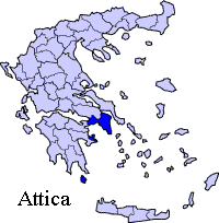
New Images

ART

.

Statistics
Prefecture: Attica
Metropolitan area: Athens
Location: 37 ° 57' 2'' N 23 ° 31' 27'' E
Population: (2001)  7060
Elevation:
 -lowest:
 -centre:
 -highest:

sea level
18 m(centre)
about 200 to 300 m
Postal code: 189 02
Area/distance code: 11-30-22980 (030-22980)-460 to 469
Municipal code: 4004
Car designation: AM
3-letter abbreviation: AMB Ambelakia
Address of administration: 2 Sikyonou St.
Ampelakia 189 02
Website: www.ampelakia.gr

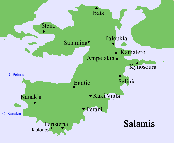
Ampelakia (Greek: Αμπελάκια, meaning vineyards), also Ambelakia or Abelakia is the capital city of the second municipality of Salamis and is in the southeastern part. It has a population of 6,000. Ampelakia has a very long history. There is the Ampelakia Bay the place of the famous battle of Salamina in 480 BC where the Greek ships defeated the great persian fleet of Xerxes. Moreover there are many remnants of the ancient town of Salamina which was financially strong between 350 and 318 BC when there were cutting coins with the shield of the legendary hero Ajax. There are churches also which date in the 16th century like St. John, St. Peter. Today Ampelakia is a city nice for walking. The majority people are sailors. However the ancient port is full of shipwrecks of old ships from the last 20 years. There is an effort from the state to clean the port and continue the excavations.

Division of the municipality of Ampelakia

  • Ampelakia / Δ.δ. Αμπελακίων [ 4.714 ]
    • Ampelakia / τα Αμπελάκια [ 4.537 ]
    • Kynosoura / η Κυνοσούρα [ 137 ]
    • Spithari / το Σπιθάρι [ 40 ]
  • Selinia / Δ.δ. Σεληνίων -- τα Σελήνια [ 2.346 ]

Historical population

Year Communal population Municipal population
1981 4180 -
1991 4174 6760
2001 4537  7060

Two-thirds of the population live in Ampelakia. Ampelakia has a school, a lyceum, a gymnasuim, a church, a post office, a port, banks, and a square (plateia).

Much of the area are made up of rocky landscapes with a few bushes, while some farmalds lie within the sea. Thre rest of the area are made up of residential areas.

The panorama of the small portion of the Attica peninsula including the Piraeus part of Athens and the southern half of the peninsula can be seen during clear days.

North: Salamis
West: Saronic Gulf
Ampelakia Salaminas East: Saronic Gulf
South: Saronic Gulf

Municipalities of Athens

Agia Varvara | Agia Paraskevi | Agioi Anargyroi | Agios Dimitrios | Athens | Aigaleo | Alimos | Amarousi | Argyroupoli | Chaidari | Chalandri | Cholargos | Dafni | Ellinikon | Filothei | Galatsi | Glyfada | Heraklio | Ilio | Ilioupoli | Kaisariani | Kallithea | Kamatero | Kifissia | Lykovryssi | Melissia | Metamorfosi | Nea Chalkidona | Nea Erythraia | Nea Ionia | Nea Filadelfeia | Nea Smyrni | Neo Psychiko | Palaio Faliro | Papagou | Pefki | Peristeri | Petroupoli | Psychiko | Tavros | Vrilissia | Vyrona | Ymittos | Zografou

(Non-municipal) Communities of Athens prefectural department

Ekali | Nea Penteli | Penteli

Municipalities of East Attica

Acharnai | Agios Stefanos | Artemida | Avlona | Gerakas | Glyka Nera | Kalyvia Thorikou | Keratea | Kropia | Lavreotiki | Marathon | Markopoulo Mesogeias | Nea Makri | Paiania | Pallini | Rafina | Spata | Vari | Vouliagmeni | Voula

(Non-municipal)Communities of East Attica

Afidnes | Agios Konstantinos | Anavyssos | Anoixi | Anthousa | Dionysos | Drosia | Grammatiko | Kalamos | Kapandriti | Kouvaras | Kryoneri | Malakasa | Markopoulo Oropou | Nea Palatia | Oropos | Palaia Fokaia | Pikermi | Polydendri | Rodopoli | Saronida | Skala Oropou | Stamata | Sykamino | Thrakomakedones | Varnava

Municipalities of the Piraeus prefectural department

Aegina | Agios Ioannis Rentis | Ampelakia Salaminas | Hydra | Korydallos | Kythira | Drapetsona | Methana | Nikaia | Perama | Piraeus | Poros | Salamina | Spetses | Troizina

(Non-municipal) Communities of the Piraeus prefectural department

Angistri | Antikythira

Provinces of the Piraeus prefectural department

Aigina | Kythira

Municipalities of West Attica

Ano Liosia | Aspropyrgos | Eleusis | Erythres | Fyli | Mandra | Megara | Nea Peramos | Vilia | Zefyri

(Non-Municipal) Communities of West Attica

Magoula | Oinoi

Retrieved from "http://en.wikipedia.org/"
All text is available under the terms of the GNU Free Documentation License

Greece

World

Index

Hellenica World