

.
Administrative Region : Attica
Regional unit : Islands
Poros (Greek: Πόρος) is a small Greek island-pair in the southern part of the Saronic Gulf, at a distance about 58 km (31 nautical miles) south from Piraeus and separated from the Peloponnese by a 200-metre wide sea channel, with the town of Galatas on the mainland across the strait. Its surface is about 31 square kilometres (12 sq mi) and it has 4,117 inhabitants. The town of Poros has 4,102 of these inhabitants. The only other inhabited settlement is Ágios Nektários (pop. 15). The ancient name of Poros was Pogon. Like other ports in the Saronic, it is a popular weekend destination for Athenian travellers.
Poros consists of two islands: Sphairia (Greek: Σφαιρία, pronounced [sfeˈria]), the southern part, which is of volcanic origin, where today's city is located, and Kalaureia (Greek: Καλαυρία, [kalavˈria]), also Kalavria or Calauria (meaning 'gentle breeze'), the northern and largest part. A bridge connects the two islands over a narrow isthmus. The Municipality of Poros also includes a part of the mainland, Kyaní Aktí (pop. 231), at the easternmost point of the Peloponnese Peninsula, between the island of Poros and the island of Hydra and next to the municipalities of Troizina and Ermioni. map The total land area of the municipality is 49.582 km², and the total population is 4,348 persons.
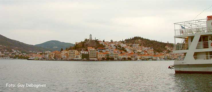
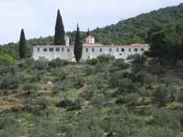
Poros (Source)
|
|
|
|
Poros is an island with rich vegetation. Much of the northern and far eastern/western sides of the island are bushy, whereas large areas of old pine forest are found in the south and center of the island. It has a good road network and adequate tourist infrastructure, which makes it a popular resort for short holidays. Though possessing no airport, it is easily accessible from Athens via ferry or hydrofoil or from the adjacent mainland at Galatas.
Geography
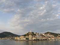
The island of Poros.
The landscape is very hilly and mountainous. The highest peak is the Vigla (358 m) in the west-central part. Following the island's topography and geology, small creeks and seasonal streams flow through steep valleys of the southern and northeastern part. The western and northern part of the island feature smooth hills and shallow valleys. Sandy beaches are restricted to the southern shore of the island, except for a bay in the northern part called Vayionia.
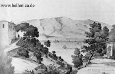
Poros with Monastery Phaneromeni 1836
Geology
The geology of the island comprises Mesozoic to Cenozoic sedimentary rocks (limestone, and Flysch-type sandstone) and ophiolites, as well as Neogene volcanic rocks on Sferia. The island is tectonically dissected and part of a Tertiary tectonic mélange. There are karstic sinkholes in the island's central limestone massif, and limestone caves with stalactites. Visible marine fossils are mainly found in the limestone, no occurrences of precious stones or ore deposits are known.
History
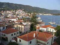
View of Poros town.
Recent studies suggest that Poros has been inhabited since the Bronze Age. Graves on the island have been dated to the Mycenaean period, and manmade structures have existed on it since at least 1000 BCE.
Antiquity
The ancient polis of Kalaureia was home to an asylum dedicated to Poseidon, the ruins of which are still accessible on a hilltop close to the town. This asylum may have been linked to the sanctuaries at Geraistos and Tainaros. Ancient historians claimed that Poros was home to an Amphictyony in the Archaic period, a league of the poleis Poros, Athens, Prassiai, Aegina, Epidaurus, Hermione, Troizen, Nauplion and Orchomenus. However, there is no evidence for this, and modern scholars believe the Amphictyony may have been a Hellenistic invention. An enormous feast was found dating to the Hellenistic period in the ruins of the Kalaureia asylum, along with a plaque celebrating the "revival" of the Kalaureian League.
Byzantine/Ottoman Era
Further information: Byzantine Greece and Ottoman Greece
In Byzantine times, Poros and other islands were often raided by pirates. During the Ottoman occupation Poros remained independent, and helped neighbouring islands after the start of the Greek War of Independence.
Russian Naval Base
With the Treaty of Kuchuk Kainarji, Russia secured free shipping for its navy, war and merchant alike, throughout the waters of the Ottoman Empire. As Russian naval activity grew, need arose for a supply station, and land was acquired at the edge of Poros town. Extensive materiel, coal, and food storage facilities were built, as well as a hardtack baking factory. After Greek independence, Governor Capodistrias requisitioned the facilities for use of the Greek war navy, and offered the Russians an alternative location in a nearby cove. The new facilities were far larger, and were used by Russian ships throughout the 19th century. The number of Russian residents of Poros increased and even a Russian school was established. Then as Russian naval activity declined, so did the base and by the early 1900s only a single Russian watchman was left guarding it. It was then granted to the Greek Navy by the Czar but was never put to actual use, and the abandoned buildings were left to decay. The ruins, in elaborately carved stone, were listed as protected architectural monuments in 1989.
Main sights
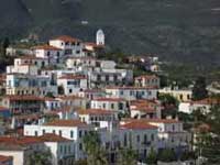
Traditional houses.
Poros Clock Tower.
The town of Poros, with its neoclassical edifices, is built amphitheatrically on the slopes of a hill. Its most famous landmark is a clock tower, built in 1927.
The Archaeological Museum at Korizis Square houses findings from the Sanctuary of Poseidon, from ancient Troizen, and from other archaeological sites nearby.
In the northern part of the island are the remains of the Sanctuary of Poseidon, the centre of the Kalaureian amphictyony. The exact date it was built is not known, although researchers estimate it to have been around 520 BC. The dimensions of the temple, which is of the Doric order, are 27.4×14.4 m. There are six columns on each short side and twelve on each long side. It was here that Demosthenes, the famous orator, poisoned himself with hemlock in 322 BC fleeing from the Macedonian Governor Antipatros.
Poros was the site of the first naval base in modern Greece, established in 1827 during the Greek War of Independence. Most of the activities of Poros naval base were moved to Salamis Naval Base in 1881. The site is still used today by the Hellenic Navy as a training centre for naval personnel.
Bourtzi castle. It was built by von Heideck at around 1828, at the place were an old church of St. Constantine stood. The island was given to the Poros monastery from 1770 on by Antonios Serfos. The stand off between Hydra island and Capodistrias gave the cause for severe fight here on 1831.[2]
Historical population
Year Town population Municipality population
1981 3,929 -
1991 3,273 3,570
2001 4,059 4,282
Notable people
Alexandros Koryzis (1885–1941) Prime Minister of Greece
See also
List of volcanoes in Greece
List of municipalities of Attica, including the Saronic
References
^ "Δείτε τη Διοικητική Διαίρεση" (in Greek). Hellenic Interior Ministry. www.ypes.gr. Retrieved 09 September 2009.
^ http://www.koutouzis.gr/mnimeia.htm
----
Poros (Πόρος)
Poros (Πόρος) Aitoloakarnania
Poros (Πόρος) Evros
Poros (Πόρος) Grevena
Poros (Πόρος) Ilia
Poros (Πόρος) Imathia
Poros (Πόρος) Kefalonia
Poros (Πόρος) Lefkada
Greece :
A - B - C - D - E - F - G - H - I - J - K - L - M -
N - O - P - Q - R - S - T - U - V - W - X - Y - Z
| Ancient Greece
Science, Technology , Medicine , Warfare, , Biographies , Life , Cities/Places/Maps , Arts , Literature , Philosophy ,Olympics, Mythology , History , Images Medieval Greece / Byzantine Empire Science, Technology, Arts, , Warfare , Literature, Biographies, Icons, History Modern Greece Cities, Islands, Regions, Fauna/Flora ,Biographies , History , Warfare, Science/Technology, Literature, Music , Arts , Film/Actors , Sport , Fashion --- |
Retrieved from "http://en.wikipedia.org/"
All text is available under the terms of the GNU Free Documentation License
