

.
| Chelmos or Aroania | |
|---|---|
| Elevation: | 2,341 m |
| Latitude: | 37.983/37°59' N |
| Longitude: | 22.183/22°11' E |
| Location: | eastern and south-eastern Achaia, Greece |
| Length: | approx. 15 to 20 km, north to south approx. from 5 to 10 km from east to west |
| Easiest route: | climb |
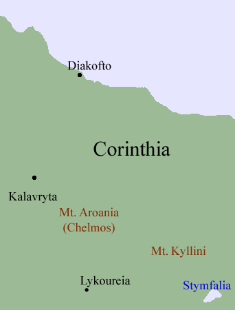
Aroania, also and commonly Chelmos, Helmos and Khelmos (Greek Αροάνεια, also Aroaneia, also Χελμός), is a mountain range that spans about 15 to 20 from north to south (north-east of Lykouria and about 10 km SW of Diakopto) and about 5 to 10 km from west to directly east of Kalavryta to the Achaia-Corinthia prefectural border. The mountain range is in the prefecture of Achaia. In ancient times, much of the mountain was part of Arcadia. In the middle ages and until the 20th century, the mountain was known as Chelmos. The mountain is home to the Kalvryta Ski Center which is in the northern part. The mountaintop is the third tallest in the peninsula. The caves of the Cave Lakes are to the west and Mega Spilaio is to the north-west. The western portion of the mountain range are encircled with the roads linking Panagitsa and Kalavryta and up to Diakopto (or Diakofto) and the interchange, south of GR-8A, the boundary in the east and Lykoureio to the south. The Kyllini mountain is directly to its east. The panorama includes the Kyllini mountain to the east, northern Arcadia to the south, the mountains to the west and the mountains to the north-west. The Gulf of Corinth is to the north. The Vouraikos river (ancient: Buraicus) flows to the north-west. The mountain also has communications tower which broadcasts television and radio stations to Kalavryta. It is about 10 km E of Kalavryta via road, S of Diakopto, SW of Akrata and NE of Lykoureia. The name of the mountain dates back to ancient times. The central part of the mountain does not have much roads. The mountaintop which is also Ostrakia elevating at 1,860 m is in the north-west central part. Chelmos is also the tallest mountain in modern Achaia. The entire area is also a parkland. The name of the mountaintop is psili and is shaped like a pyramid with a head while it has a shoulder in the lower part.
The mountain ranges includes insects like the Chelmos blue (Agrodiaetus iphigenia) which is founded between 1,100 m and 1,800 m
Mountaintops
- Mikros Chelmos
Nearest places
- Lykoureia, SW
- Planitero, SSW
- Kalavryta, W
- Kato Louses, west northwest
- Sinevro, NE
The geography of the Chelmos are forested between 800 m and 1,800 m with a type of pine trees in the western and the eastern part along with the southern part. North of the mountain range also has forests and many hilltops and mountaintops along with valleys and streams. Areas over about 1,500 m are barren land in the central part and grasslands and rocks dominate the eastern part and some parts. Most of the mountain are forested and grassy.
The municipal boundary between Akrata and Kalavryta, Diakopto-Akrata to the northwest and Lefkasio to the southwest.
Other
The municipality of Aroania and the village lies southwest of the mountain range. The seat of the municipality is Psofida. The Greek spelling is different and does not have an e between the n and the i.
Maps of Chelmos Mountain Paths
| Ancient Greece
Science, Technology , Medicine , Warfare, , Biographies , Life , Cities/Places/Maps , Arts , Literature , Philosophy ,Olympics, Mythology , History , Images Medieval Greece / Byzantine Empire Science, Technology, Arts, , Warfare , Literature, Biographies, Icons, History Modern Greece Cities, Islands, Regions, Fauna/Flora ,Biographies , History , Warfare, Science/Technology, Literature, Music , Arts , Film/Actors , Sport , Fashion --- |
Retrieved from "http://en.wikipedia.org/"
All text is available under the terms of the GNU Free Documentation License
