
.
UNITED STATES DEPARTMENT OF THE INTERIOR
NATIONAL PARK SERVICE
HISTORICAL HANDBOOK NUMBER TWENTY-SEVEN
This publication is one of a series of handbooks describing the historical and archeological areas in the National Park System administered by the National Park Service of the United States Department of the Interior. It is printed by the Government Printing Office and may be purchased from the Superintendent of Documents, Washington 25, D. C.
For sale by the Superintendent of Documents, U.S. Government Printing Office
Washington, D.C. 20402
Stock No. 024-005-00176-0 / Catalog No. I 29.58:27
MONTEZUMA CASTLE
NATIONAL MONUMENT
Arizona
by Albert H. Schroeder and Homer F. Hastings
NATIONAL PARK SERVICE HISTORICAL HANDBOOK SERIES NO. 27
Washington, D. C. - 1958
(Reprint 1961)
The National Park System, of which Montezuma Castle National Monument is a unit, is dedicated to conserving the scenic, scientific, and historic heritage of the United States for the benefit and enjoyment of its people.
Contents
- Page
- FORCES OF EARTH 1
- MAN IN THE VERDE VALLEY 4
- SINAGUA PUEBLO LIFE 11
- MONTEZUMA CASTLE 19
- MONTEZUMA WELL 26
- HISTORY OF THE MONUMENT 31
- THE NATURAL SCENE 33
- HOW TO REACH THE MONUMENT 36
- ABOUT YOUR VISIT 36
- RELATED AREAS 36
- ADMINISTRATION 38
- GLOSSARY OF SPANISH AND INDIAN WORDS 39
- SUGGESTED READINGS 40

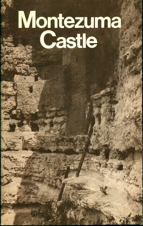
Montezuma Castle.
MONTEZUMA CASTLE, a pueblo ruin in the Verde River valley of central Arizona, has no connection with the Aztec emperor whose name it bears. The name was given by early settlers in the Verde Valley in the belief that the striking 5-story ruin with its 20 rooms had been built by Aztec refugees, fleeing from central Mexico at the time of the Spanish conquest. It follows naturally that the small lake inside a hill 7 miles away should be named Montezuma Well. While the story of the flight is known to be false, the names remain.
The aboriginal builders of the Castle left no records, but they did leave broken pottery, trash, and other debris of their everyday life. The analysis of this material tells us that these people, whom we call Sinagua (see glossary), were peaceful farmers who occupied this area from the 1100’s until the 1400’s; that they were similar in physical type to many of today’s Pueblo peoples in northern Arizona and New Mexico; and that they differed somewhat in their daily life from their neighbors in the desert to the south and in the mountains and plateaus to the north.
This is their story, and we hope that it can take you back in your mind’s eye to the time when their fingers left marks as they plastered the walls of Montezuma Castle, and to the time when their fires left the smoke deposits you still see on those walls. But this story must begin with the land itself....
Forces of Earth
Montezuma Well and the cave in which Montezuma Castle is built both exist today because of a series of events that began over 1 million years ago. A flow of lava coming from the Black Hills at the south end of the Verde Valley closed the narrow canyon through which the Verde River then ran. This formed a natural dam and the river backed up against it to form a lake. Other rivers farther upstream added more water, and carried in large quantities of dissolved limestone from the higher elevations which they drained.

Bird’s-eye view of Verde Valley landscape and geology.
Consequently, in late Pliocene times (perhaps 1 million years ago), the Verde Valley was covered by a shallow lake or marsh 25 to 40 miles long and 12 to 15 miles wide. Its extent can be determined by noting the boundary between the light-colored sedimentary limestone and the dark basalts or the red sandstone marking the old shoreline.
This light-colored rock was redeposited from the original limestone beds upriver and, therefore, the entire formation is almost devoid of fossils. Well preserved cougar tracks, however, imbedded in a slab of limestone, were found a few miles north of Montezuma Castle near Cornville, Ariz.
When the lake was at its maximum size the water reached a height where it began to flow over the top of the lava dam. During thousands of years of spilling over, the water gradually wore down through the lava until the entire lake drained away. The limestone that had been carried in and deposited on the lake bottom then became the new ground surface.
Salts left by the evaporation of water were also deposited on the lake bottom. A deposit of this type can now be seen near Camp Verde. Although the formation is principally sodium carbonate, sodium chloride (common table salt) and sodium sulphate are also found. For many centuries early Indians mined salt deposits in this locality and a few years ago a deposit of sodium sulphate near Camp Verde was worked commercially.
The same streams which brought lime in solution to the lake were sometimes turned into torrents by desert cloudbursts. At such times, they became muddy and left sand and silt among the lime deposits which were accumulating on the bottom of the lake. When the lake drained away, these deposits were exposed to erosion—the clay and silt were softer than the lime and eroded more rapidly leaving irregular cavities and caves of all sizes. It is in one of these caves that the Indians built Montezuma Castle.
Today the pitted and jagged surface of the cliff appears like crumbling limestone. In places it is so soft it can be removed by the pressure of a finger.
After the ancient lake drained, rain and melting snows from higher elevations continued to find their way into the valley where the water seeped below the ground, dissolving the limestone as it went. Underground river channels and caves were slowly formed by this water.
One such channel, leading from a cave, was eventually cut through from the surface by the eroding waters of Beaver Creek. This allowed 4 the water in the underground cave to pour out into the creek. The roof of the cave, weakened by the removal of this water and by solution cracks forming from the surface, soon collapsed to form Montezuma Well as it is seen today. It is due to this action that the Well is technically referred to as a limestone sink.
Thus the slow, but powerful forces of earth shaped the Verde Valley into a congenial environment for man.
Man in the Verde Valley
The first human occupation of central Arizona began several thousand years ago. Very little is known about these Indians, but there is archeological evidence which indicates that they were hunters and food gatherers. These people had no pottery, and probably had no permanent houses or farms. The only objects recovered from their campsites have been their crude stone tools. One such site was discovered and investigated a short distance north of Montezuma Castle National Monument in 1949.
Shortly after A. D. 600, the Verde Valley attracted another group of people. They were farmers who came from the south, near the vicinity of modern Phoenix. We call these people of southern Arizona, who were the first known permanent settlers in the Verde Valley, the “Hohokam.” They planted their crops in the bottom lands and built their houses on the adjacent terraces so they could overlook their fields. Their homes of poles, brush, and mud were individual dwellings large enough to house one family.
Utensils in the home were few, but important. They consisted of plain, unpolished, gray-brown pottery, used to hold water and food; grinding stones on which corn, nuts, and berries were ground; and hammerstones for crushing or mashing food. Also, such objects as scrapers for working hides, points for arrows, and knives for skinning game have been recovered by archeologists.
The Hohokam built a specialized structure not found among other prehistoric Indians of the Southwest. It was a prepared court, oval in shape, which bears a close similarity to the ball courts of Mexico. They may have played a game of some type on these courts which had some connection with their ceremonial rites, such as appears to have been the case in Central America. These people also had another trait which set them apart from other tribes—they cremated their dead.
There is no evidence of Hohokam occupation at Montezuma Castle, but remains of Hohokam type are found at Montezuma Well. We can imagine that a party of Indian colonists, about 1200 years ago, was very pleased to discover the Well and was as startled as we are to find a lake inside a hill.
In looking further, the Hohokam found the outlet on the south side of the Well through which a steady stream of water flowed, falling into Beaver Creek a few feet away. Here was a place to live! If this water could be diverted to the nearby flatlands, they would no longer need to depend on rain for their crops.
The Indians set about their task. They fashioned some stone hoes and dug a small section of ditch at the base of the cliff between the Well and Beaver Creek. After reaching the proper depth, a brush dam was made and the water was diverted from the outlet. Eager eyes watched the water enter and gradually fill their ditch. Another section was dug and water was again turned into it. High spots were noted and dug lower so the water would flow through. Rocky obstructions were broken with stone picks and river rocks. Sometimes the ground was too hard for their hoes, and water was allowed to flow in to soften it. Gradually their ditch was lengthened until it reached the flats which they planned to farm.
Their work was not yet complete, for the fields had to be cleared. Brush was cut, and fires were built at the base of large trees to burn the trunks until they weakened and fell.

Aerial view showing Montezuma Well and Beaver Creek.
Rocks which were cleared from the farm areas were lined up to mark the edges of small plots. Dirt was thrown over these rocks so water 6 would not escape when the plots were irrigated. Some of the brush was saved for making dams to divert water from the main ditch to each of the farm plots. Small limbs from fallen trees were fashioned into digging and planting sticks. The fields were leveled with their stone hoes and tree limbs were dragged over the soil in a final smoothing process.

Yucca-fiber sandal made by prehistoric Indians of Montezuma Castle.
Finally they were ready for their planting. They had brought seeds of food crops—corn, beans, and squash—which were planted in these plots. Cotton was also planted. Then the water was turned onto the fields to complete their labor.
During the course of their pioneering work, this small group of Indians probably lived on the edge of the bluff above the fields and in three small caves along the bluff bordering their ditch. Food was not lacking, as the plants in the area provided them with many essentials. Mesquite beans, a common staple among the Indians, were plentiful in the late summer and autumn, as were walnuts, berries, wild gourds, and sunflower seeds.
Other plants, particularly yucca, supplied necessary fibers for making sandals, matting, cordage, baskets, and other articles. Reeds and hardwoods were available to make bows and arrows and other wooden implements for hunting rabbits and ducks around the Well. Hunting parties no doubt went to the foothills for larger game such as deer.
At about the same time that the Hohokam were in the valley, another group of Indians whom we call the “Sinagua,” lived in the forested foothills to the north and east, and on the plateau above. Their small villages were located in open areas that could be dry farmed, as 7 they depended on rain water for their crops. Their houses, like those of the Hohokam, were made of poles, brush, and mud; however, they were dug into the ground, with just a small portion of the walls and the roof projecting above the ground level.

Sunset Crater north of Flagstaff.
Their utensils and habits were similar to those of the Hohokam, though different in some respects. For example, in contrast to the Hohokam practice, the Sinagua polished their plain brown pottery. Also, it is known that after 1070, they buried their dead in an extended position instead of cremating them as the Hohokam did. Although the Sinagua were basically farmers like the Hohokam, at this time they depended to a greater extent on foods they gathered and meat they hunted than they did later.
About 1070, some of the Hohokam left the valley. Evidently many of these emigrants went north to the plateau region east of present-day Flagstaff, to plant in the moisture-conserving ash-fall area created by the eruption of Sunset Crater in 1064. Shortly after these Hohokam departed, many of the Sinagua moved down from the hills into the middle of the Verde Valley. This occurred about 1125. They lived much as they had before, but with two important changes: they 8 adopted the Hohokam idea of irrigation, and they began building surface houses of rock and mud—an idea acquired from still another group, the Pueblo Indians, farther north. These Sinagua were the people who built the stone pueblos we find in the valley today.
At first they erected small settlements on well-drained ridges overlooking their farmlands. Occasionally, also, caves were utilized for dwellings; the first 3 or 4 rooms of Montezuma Castle were evidently built in the 1100’s.
From 1125 to 1200, the settlement at Montezuma Well was increased by groups of these Sinagua Indians who had left their homes in the foothills to the north and east. It appears that they joined some of the remaining Hohokam, as several customs of the latter survived up to 1400. In this period the Sinagua also utilized caves near their fields, and built a small pueblo on the west rim of Montezuma Well. Limestone rock for their masonry was available on the rim of the Well, and river boulders for foundations were taken from the creek. Mud and clay, which they mixed for their mortar, were easily obtained along the creek.

Ancient irrigation ditch near Montezuma Well.
As the years passed, more land was put under cultivation and more ditches were constructed. To insure adequate care of their farmland, 9 1- and 2-room “farm” structures were built on the slopes above and along the course of the main ditch. From these, the occupants were able to view the fields while irrigating and also could divert the water from the ditch below them whenever necessary. At their peak, the people at Montezuma Well were farming about 60 acres, or possibly more, and their main ditch was about 1 mile long.

Cut-away model of Montezuma Castle.
The Sinagua of the Verde generally lived in small pueblos until about 1250, at which time the center of the valley appears to have undergone a “real estate boom.” The buildings increased in size, and many of them were converted into forts with defensive walls, parapets, peepholes, and sealed doorways. Since the pueblos on the north and east fringes of the valley were abandoned in the 1200’s, it is believed that the Sinagua of that area probably were the ones who moved in to increase the population and size of the central villages.
This move to the center of the valley was probably caused by nearly a century of almost continuous drought which began about 1200 and culminated in an especially severe drought from 1276 to 1299.
Many of the Sinagua in the modern Flagstaff region to the north began to leave their dry-farming area in the early 1200’s. They also 10 seem to have migrated into the Verde Valley. Since they had depended on rainfall for their crops, it is quite possible that the drought affected their entire area, forcing them to move down from the Flagstaff area as well as from the northern and eastern parts of the valley. The occupants of the central region of the valley were able to survive because of the spring-fed streams upon which they depended for their irrigation and water supply.
Such a move undoubtedly disturbed the balance of the people and the available food in the now overcrowded central area. Considerable friction must have arisen. The combination of too many people and not enough farmland may have eventually caused intervillage strife over water rights, with general population decline caused by soil exhaustion and the reduction of other resources.
Montezuma Castle was built up to its present size at this time, reaching its maximum in the 1300’s. Consolidation was also in progress at Montezuma Well. Between 1300 and 1400, only 3 farm outlooks along that half of the irrigation ditch nearest the Well were occupied. In this way the area of settlement was contracted or reduced by abandonment of outlying sites. The concentration of population around the Well implies conflict of some sort; and, it was at this time that the large, definitely defensive pueblo on the rim was constructed. By 1400, or shortly thereafter, the Sinagua abandoned the Well.
Shortly after 1400, in fact, Montezuma Castle and the entire Verde Valley were abandoned by the Sinagua. There is no direct evidence to supply us with the reason for this complete exodus—a combination of circumstances is the probable answer.
A possible major factor causing the Sinagua to abandon the area may have been the Yavapai Indians whom the Spanish later encountered in the Verde Valley. The Yavapai could have been descendents of those Hohokam who had stayed in the valley and lived with the Sinagua between 1100 and 1400. (Like the Hohokam, the Yavapai cremated their dead, built pole-and-brush houses, and farmed small plots along the stream bottomlands.) If they were descendents of the Hohokam, the Yavapai might have been the victors in the intervillage strife that apparently occurred during the 1300’s and forced the Sinagua to leave the valley.
Whatever the real reason, when the Sinagua left, they moved northeast and it is thought they eventually joined the ancestors of the modern Hopi Indians. Before the exodus, the Sinagua had obtained a black-on-yellow pottery from the Hopi country, so they knew the Hopi through their trade contacts. Oral traditions also indicate the possibility of such a move. The modern Hopi have legends of a people coming up from the south to join them. They say that these people were great warriors and that they had no priests or ceremonies. Since the Sinagua had no underground ceremonial chamber, or kiva, such as 11 that of the Hopi, and since we lack evidence of ceremonialism among the Sinagua, these legends could well apply to them.

Woven black-and-white cotton bag.
Early Spanish explorers remarked on the vast amount of cotton grown and woven by the Hopi. The Sinagua had been great cotton growers and expert weavers while they lived in the Verde Valley. They may have been responsible in part for such a development among the Hopi, first through trade and later by actually joining the Hopi.
Whatever the fate of the Sinagua, the Yavapai were in the Verde Valley when the Spanish reached the area in 1583. They described wild, but peaceful and friendly Indians in the region, living in huts instead of pueblos, planting corn, and hunting game. Similar references are made by later explorers. Although the names given them in the old Spanish documents are quite different, these people presumably were the Yavapai.
Still later, the Western Apache came into the story of the Verde Valley. Just when they entered central Arizona is unknown; but since the 1860’s, certain Western Apache bands ranged as far west as the Verde. Two small caves at Montezuma Well show indications of Apache occupation, probably after 1800.
Sinagua Pueblo Life
The pre-Columbian Indians of the Southwest (northern Mexico to southern Utah and Colorado; eastern New Mexico to western Arizona) 12 were, in general, settled and apparently peaceful farming peoples living in villages. The agricultural staples—corn, squash, and beans—were supplemented by gathering wild plants and hunting game. The main hunting weapon was the bow and arrow. Weapons and tools were made of various kinds of stone, animal bones, and wood. Pottery and basketry were used for utensils or containers.

Montezuma Well showing collapsed ruin on opposite rim.
Clothing included garments woven from cultivated cotton and a variety of bands, sandals, and other apparel made from yucca and other wild plants; animal skins also were utilized. Ornaments and ceremonial paraphernalia were made from such materials as turquoise, animal bones, imported sea shells, and brightly colored bird feathers.
Implements and utensils found in the houses of these people include such objects as stone metates and manos for grinding corn, hammers, knives, drills, bone awls and needles, baskets, and many ornaments of shell and turquoise, often carved in bird and animal forms.
Items missing from the pre-Spanish Indian culture include metals, livestock, wheeled vehicles, and writing.
Life in the Sinagua pueblos of the Verde, though lacking the variety found in a modern city, had more of natural beauty and simplicity. Like any other people, the Sinagua would not have selected this spot for their homes if the necessities of their everyday life had not been 13 present. In this region, their needs were filled by a good water supply, bottomlands for farming, wild berries and edible shrubs, game for meat, and materials for buildings, pottery, and tools.
In addition, they had one thing which most Indians in Arizona had to travel great distances to obtain—a large deposit of salt. This they mined a few miles southwest of present-day Camp Verde where their collapsed tunnels can be traced even today. Occasionally the handle of a stone pick may still be seen projecting from a collapsed tunnel. Many bits of matting and unburned torches that the Indians apparently used for lighting their tunnels have been recovered. In 1928 several well-preserved Indian bodies were removed from one of these mines where they had been trapped when one of the tunnels caved in.
The Sinagua also were fortunate in having a deposit of a red rock called argillite not too far away. From this material they fashioned stone pendants, beads, earrings, and other ornaments with which they adorned themselves.
To satisfy their vanity further, the Indians imported luxuries not available in this area. Bracelets, pendants, beads, rings, and inlay made from shell were acquired by trade with tribes to the south who obtained the shell from the Gulf of California. The Sinagua also bartered for turquoise pendants, earrings, beads, and inlay pieces from other groups. Probably their greatest trade was in pottery. These Sinagua Indians rarely decorated their pottery, and judging by the quantity of painted pieces recovered from their sites, they engaged in lively trade for the wares of their northeastern neighbors. One might say that they imported their “china” in quantity.
Through a study of this pottery we find that from about 1150 to 1250, decorated pieces were obtained from the Indians in the north, near modern Flagstaff. Some of this pottery the Sinagua retraded to the Hohokam around present-day Phoenix. (How many of us today would be successful in taking dishes over a distance of 200 miles on foot without breaking a goodly portion?) After 1250, due to depopulation east of the Flagstaff area, the people of the Verde Valley obtained decorated pottery from the region farther east, around modern Winslow; and also, farther north, from the present Hopi Indian reservation area.
The trade possibilities of the Sinagua were almost unlimited. They were located between the large Hohokam settlements of southern Arizona and the widespread pueblos of northern Arizona. Natural routes of travel along streams led them into both areas, and they had salt, argillite, and cotton to offer in exchange.
Despite the importance of trade, which was primarily for luxury items, the Sinagua Indians were basically farmers and depended mainly on food they raised themselves. In Montezuma Castle, American pioneers found corncobs in abundance and sometimes the remains of beans and squash. There were also numerous corn-grinding stones or metates, made from basaltic boulders carried into the area by flood waters in Beaver Creek. Roughly rectangular, the stones measure about 14 by 18 inches, and are 6 to 8 inches thick. Corn was ground by rubbing a smaller stone (mano) back and forth on the metate. This process gradually wore a trough down into the metate.

Montezuma Castle artifacts including piece of gourd with carved handle, squash, cotton bolls, spindle, and corn.

Jars, metates and manos, and fireplace as found in excavated ruin at cliff base west of Montezuma Castle.
The people also were gatherers and hunters to some extent. Remains of hackberries, mesquite beans, black walnuts, and sego-lily bulbs have been found in the cliff dwellings. Mescal or agave (sometimes called century plant) was used. Small wads or “quids” of fiber from this plant have been found; they were chewed by the Indians to extract the sweet juices.
Although identifiable animal bones from Montezuma Castle and nearby dwellings are rare, they have been found in other pueblos in the valley. From a site about 10 miles away, bones of elk, mule deer, antelope, bear, rabbit, turtle, and fish have been recovered.
Some food for winter use must have been held in storage. Probably the Castle dwellers, like the modern Hopis, stacked mature corn on the cob across the end of a room like cordwood. Strings of squash, cut into rings and dried in the sun, were probably strung from the roof in an out-of-the-way corner. Meat was undoubtedly preserved in a similar fashion—by drying rather than smoking or salting it. Perhaps the stores of food and the seed held for the next spring’s planting were sought by neighboring pueblos where crops may have failed. As pointed out earlier, food shortages could have provided one of the principal reasons for intervillage warfare, especially after 1300 when the area became overcrowded.
Cooking fires were kindled by the friction of a wooden spindle rotated in a hearth stick until enough heat was generated to ignite tinder. Perhaps some family in Montezuma Castle was responsible for maintaining a perpetual fire from which embers could be carried to other households. This is not so strange when we recall that only 100 years ago pioneer neighbors sometimes called on each other to borrow a coal of fire.
These Sinagua Indians were artisans who manufactured pottery, and stone and shell ornaments. Their pottery was a reddish-brown ware (so colored from minerals in the native clay) and it was usually undecorated, though sometimes painted red. Sand was used as a tempering or binding agent. They made pottery bowls, cooking pots, and water jars—some of the latter of 3- or 4-gallon capacity. In refuse dumps near the dwellings, archeologists have found quantities of broken pottery—it is principally through a study of these dumps that the chronology of Indian occupation in this area is revealed.
Pottery was made from clay found in the region. After the clay was pulverized, the correct amounts of water and tempering materials were added. There were no potter’s wheels, so the vessels were shaped 16 by hand. The Sinagua accomplished this with the aid of a stone “anvil” held inside the pot and a wooden paddle used against the outside. Finishing was usually done by rubbing the surface perfectly smooth with a polishing stone or pebble dipped in water. Although some Indian pottery has a high polish, none of it carries a true, over-all glaze.
Modern Indians, in firing their pottery, usually burn animal dung for fuel, but the pre-Columbian Indians used vegetable material, possibly juniper wood. Several pieces of pottery might be stacked together so that all would be evenly exposed to the heat of the fire. Large pieces of broken pottery were used to protect the new pieces from direct contact with the flames. The firing process required several hours, with time allowed for the pottery to cool slowly.
Stone and shell ornaments are examples of other crafts, and some beautiful specimens have been found. The shells came from the Pacific Ocean or the Gulf of California and are believed to have been imported through trade with neighboring tribes. Prehistoric trade routes, over which specific types of shells were distributed, extended from the Gulfs of Mexico and California to north-central New Mexico and from the Pacific Ocean to southern Utah.
The shell was worked in various ways. The tips were ground from olivella shells which were then strung on sinew and worn as beads. Larger shells were sometimes covered with a mosaic of turquoise and colored stones. The turquoise was mined with stone tools, and by the time it was removed from its matrix, cut, and polished, it represented a considerable investment of labor. Argillite found in the Verde River region was also mined. Lac, an insect secretion found on creosote bushes, was sometimes used to cement the turquoise and argillite to the shell base.
The Sinagua also excelled in the art of weaving. They wove sandals, baskets, mats, and cotton fabrics. Some of the latter exhibit lace-like open work while other pieces are tightly woven resembling modern canvas. Cotton was raised here, near the fields of corn, and woven by the Sinagua into the finished articles. A few cotton bolls with lint and seeds have been found in the dwellings.
Instead of spinning wheels, the Indians used a wooden spindle about the thickness of a lead pencil and perhaps 18 inches long. About 5 or 6 inches from one end there was a disc- or sphere-shaped counterweight made from a piece of wood or pottery. Corded cotton was spun into yarn by feeding it onto the end of the spindle as it was twirled between the thumb and fingers, or, between the hand and the thigh as the spinner sat on the ground.
Among the modern Indians of the Southwest, the most and the best weaving is done by the Navajo, an Apache people who learned weaving only a few hundred years ago from the Pueblos. Modern Navajo weaving is done by the women. Weaving among modern Pueblos, notably the Hopi, is done by men; and ancient weaving of pre-Spanish Pueblos may have been men’s work also.

Bird-shaped ornament of turquoise mosaic on seashell.

Pre-Columbian weaving with openwork design.

Child burial in floor of third-story room in Montezuma Castle.
Most weaving required the use of a loom, a rectangular vertical framework somewhat larger than the size of the finished product. Proper tension on vertical (warp) threads was maintained by lashing at the ends of the loom. Black and white patterns were known, and some red was used. The museum at Montezuma Castle exhibits some of the finest examples of prehistoric Pueblo Indian weaving.
The Sinagua Indians in the Verde Valley apparently had no formal cemeteries. Children were often buried near the dwellings or under the floor. We learn from modern Pueblo Indians that some prefer to bury a child near the home. This comes from the belief that the child’s spirit will remain until the death of the mother and can then be guided safely to the hereafter; or, that it will return in the person of the next baby to be born in the family. Occasional child burials were found in wall cavities in the pueblo ruin at Tuzigoot National Monument. Tuzigoot is a few miles northwest of Montezuma Castle and was occupied during the same general period.
Adults were buried in the refuse dump near a settlement, or placed in a cavity or under a ledge along the base of a cliff. Most bodies were buried at full length, lying on the back, and were generally accompanied 19 by offerings or grave gifts. Pioneers reported several burials beneath floors in Montezuma Castle, and one additional burial was located in 1939. It contained the remains of a child about 5 years old, which had been wrapped first in a cotton blanket and then in a yucca leaf mat. The child had been buried in the corner of a room about 2 feet below the floor level. Some rooms in Montezuma Castle were built directly above others; therefore, no floor burials were possible in these upper rooms. This might explain why one shallow grave was found on a narrow ledge at the base of the building. The mummified remains of a 2-year-old child from this grave can now be seen in the museum.
The undercut graves dug into soft bedrock at Montezuma Well constitute one of the unusual features of that area. Sometimes similar individual burials are found in other Indian ruins. In contrast to most sites, including others in the Verde Valley, there is at the Well a fairly definite cemetery—an area in which these peculiar graves are concentrated.
Now, let us turn from the general story of customs and way of life to a detailed description of the Castle and the Well.
Montezuma Castle
Montezuma Castle is one of the best preserved cliff dwellings in America. About 600 years ago, it was an apartment house occupied by perhaps 45 or 50 individuals.
The Castle might be called a 5-story structure, though there is no place where 5 stories have been built directly above each other. It is actually a 4-story building of 17 rooms, plus a “basement” of 2 store-rooms. The building was fitted into the ledges of the natural cave in such a way that it appears terraced. There are 2 rooms in the first story, 4 in the second, 8 in the third, 3 in the fourth, and 2 in the fifth.
The Indians had 2 trails that led to the Castle: 1 leading up from the creek bottom and the other coming in along the face of the cliff to the top of the first ledge. Overlooking the point where the upper and lower trails join are 2 smoke-blackened cave rooms which are too small to be dwellings. Perhaps these held sentries to guard the trails at night.
Geologists believe the cliff has changed but little since the Indian occupation. If so, the Indians must have used ladders to make numerous trips to their dwellings each day. In addition, ladders had to be employed in the building to go from one floor to another. No original Indian ladders are known to have been found at Montezuma Castle. Ladders found at other Indian dwellings, however, indicate that two types were known—single logs with notches cut into them, and a type made by lashing rungs across upright poles.

MONTEZUMA CASTLE AREA
The walls of Montezuma Castle are formed from rough chunks of limestone laid in mud mortar which was probably made from pockets of clay found in the vicinity. After the clay was pulverized and mixed with river sand and water, it made an excellent mortar. The walls average about 12 inches thick throughout the building and are curved to conform to the arc of the cave in which the Castle rests.
Walls were constructed on the very edge of the ledges with enough earth fill behind to provide level floor space. Since most of the building material had to be carried up from the base of the cliff, the individual building stones were rather small, usually no larger than two bricks. The walls were covered with mud plaster, both inside and out. Most of this has weathered away on the outside, but the plaster is well-preserved inside. In some places, finger marks of the original builders may still be seen.
Rooms have an average of about 100 square feet of floor space. The smallest room is in the second story with 37.5 square feet of floor space, and the largest is in the fifth story with 240 square feet.
What is now the fifth story is in the deepest part of the cave and apparently was the first part of the Castle to be constructed. At this point the cave extends in from the face of the cliff for 33 feet. Solid rock forms the roof and back wall of the room while the ends and outside wall are of masonry construction. This room is almost too large to have been a dwelling because it would be hard to heat in winter, but it might have been intended for joint occupancy by 2 or 3 families—perhaps while other, smaller rooms were being built.
The Castle was constructed by people who had no metal tools of any kind. Their picks were pointed stones about as long as an adult’s hand, and their stone axes were about the same size. A shallow groove was ground three-fourths of the way around these implements; then a short stick handle was bent in a J-shape and lashed on over the groove.
Some of the roof timbers still bear chopping marks. With each stroke of the ax the Indian made little progress, and cutting a large timber must have consumed considerable time. Some logs are about 1 foot in diameter and up to 10 feet in length. Ropes were probably used to pull the timbers into place since fragments of fiber ropes have been found in the excavations. Without pulleys, great physical effort must have been required to lift the logs into the cave.
Resting on the main rooftimbers and laid at right angles was a covering of poles and over this a layer of coarse grass or willows. On top was placed a layer of mud 3 or 4 inches thick. Most of the original mud floors have been worn out by early visitors.

Vertical cross section of Montezuma Castle.

Floor plan of Montezuma Castle.

A doorway in Montezuma Castle.

Smoke-blackened ceiling in Montezuma Castle.
When the weather was cold, the Indians could safely build their fires indoors on the floors. However, they sometimes used one spot for too many years and wore a hole through the mud floor. The fire would then find its way through to the willows or grass underneath, and there it could smolder for hours without being discovered because the odor of smoke was common within the building. There are several places in the building where fires of this type occurred.
Pioneer visitors supposed that a group of pigmies constructed the Castle because the doors are so small. This is not the case. Studies of the skeletal remains show that the men averaged about 5 feet 4 inches in height. Like many modern Pueblo Indians, they were short but not abnormally small. Doors throughout the building are low for at least two good reasons: they helped keep out the cold, and they would also force any attacker to put his head through first or to back through, which would make it possible for even a woman to defend her home.
There were scarcely any openings in the building to supply light and fresh air—only a few close to the floor level. The Indians had no chairs or tables; like about half of the world’s population today, they lived on the floor. Probably most of the cooking was done outside on balconies and rooftops, but when weather was cold, fires were built inside in open pits on the floor. There was no chimney or smoke vent, so smoke drifted out the door. Much of it stayed in the rooms, which accounts for the smoke-blackened condition of the walls and ceilings.
There is now no soot on the ceiling of the largest fifth-story room. Presumably it was very black at one time, but the large numbers of bats which cling there in the warm months have probably rubbed the soot off through years of continuous use. They have long occupied the room, for pioneers found 4 feet of droppings covering the floor.
An interesting feature of this room is what appears to have been a shelf. Timbers projecting from the walls were covered with a layer of poles and sticks and over this a layer of mud.
On the wall of another room is an interesting pictograph incised in the mud plaster. This roughly rectangular figure measures about 6 by 8 inches, and is laid off into 4 sections by lines that intersect at the center. In the upper left quarter and the lower right quarter are vertical wavy lines that suggest water.
Sixty yards west of Montezuma Castle, on a lower ledge, was a cluster of 6 or 8 rooms. The walls have all collapsed and only a few traces of foundation and fallen building stones indicate the location of these homes.
The next settlement down the creek west of the Castle was once a 6-story building with perhaps 40 rooms. This was not a cliff dwelling, but a structure built against the base of the cliff. The roofs were burned and all the walls collapsed, leaving only a great heap of rubble. Evidently part of the building was abandoned long before it burned, 26 for archeologists found that charred roof timbers had fallen on some floors already covered with drifted sand and dust. This ruin was excavated in 1933-34 under the direction of Archeologist Earl Jackson. Many artifacts were brought to light and are now exhibited in the museum. These are of the same type as those found in the Castle, and both places must have been occupied at the same time. Probably no more than 300 Indians lived in the neighborhood of the Castle at any one time—somewhat more than the maximum population at Montezuma Well.

Metates and manos, and burned ceiling beams as found in excavated ruin at cliff base west of Montezuma Castle.
Montezuma Well
The appeal of Montezuma Well consists largely in the sudden vision of a lake and large trees inside a barren hill in a dry region. This limestone sinkhole (or solution basin) in which a large spring flows is an unusual geological feature of considerable scientific interest.
In 1871 a U. S. Geological Survey party visited the Well. Although they thought themselves the first to explore it, they found a paper collar on the floor of a nearby cave dwelling! The area was first brought to public attention by Richard J. Hinton in his Handbook to Arizona, published in 1878.

Looking across Montezuma Well to ledge ruin.
Aside from its geological interest, this area is a monument to the ingenuity of the former Indian inhabitants. Here they built their homes around the lake from which water was diverted into irrigation ditches for purposes of watering their farms.
Today the rim of the Well is 70 feet above the surface of the water. The lake measures over 400 feet across and the springs feeding it flow continually. Nature, in this manner, provided the Indians (and later settlers) with a huge supply of water for irrigation of the dry desert soil.
In May 1948, a diver went down into the Well to determine its depth and explore the bottom. After coming up from the first dive, he said the water was so warm that he had to remove all clothing except for his swimming trunks. The temperatures at the bottom and on the surface differ by some 4° to 7° in summer. On surfacing from another dive, he remarked that the black muddy bottom was broken by two white mounds of sandy material near the west shore, and that the water in this region was cool. Continued search in this spot did not reveal an actual inlet to explain the cool water or the presence of the limestone mounds, which may have been inlets at one time. Several descents revealed the saucer shape of the Well and a maximum depth of 55 feet near the center.

MONTEZUMA WELL AREA
APRIL 1958

Diagram of undercut grave at Montezuma Well.
The Well has a constant flow at the outlet spring of 1½ million gallons of water every day. A person viewing this cup-shaped depression, half filled with water, could easily doubt this statement of flow, for the surface presents a placid and serene appearance. The water, acting like a giant mirror, reflects the blue Arizona sky, and stimulates visiting photographers to take many pictures.
On the rim, and in the ledges and caves below, are remnants of former Indian homes—reminders that in the past this body of water stood for more than natural beauty. Its presence made possible a thriving farming community of about 150 to 200 Indians between 1125 and 1400.
Archeological features include the remains of two pueblos on the rim of the Well. The larger contained about 24 ground-floor rooms, and the other 15. Three small cliff dwellings are located in the western ledges and several rooms are hidden in a large cave near the place where the Well water goes underground before emerging at the outlet spring.
Two burial grounds have been discovered, one on the flat below the Well, and the other near the small pueblo. As mentioned in a previous section, the method in which the Indians at Montezuma Well buried adults was rather unusual. They excavated a rectangular pit in the ground, roughly 3 by 6 feet. About 3 feet below the surface, they broke through a fairly hard 8- to 10-inch limestone layer commonly found underground in this area. After digging about 2 feet below this layer, they dug to one side, underneath the limestone, forming an undercut grave. This was made large enough for the 30 body to lay at full length inside, and to accommodate funeral offerings, usually including pottery vessels. The undercut portion was closed with 3 or 4 large slabs of limestone, which were sealed with mud to prevent any dirt from entering. Then the pit was filled with dirt to complete the burial. Nowhere else in the Southwest are undercut graves quite like these found.

Modern irrigation ditch flows beside lime-coated bank of ancient irrigation ditch.
Along the north edge of the farmland you can see the most unusual feature at Montezuma Well: “fossilized” irrigation ditches of the ancient Indian farms! The water in the Well is warm and contains much lime. As the water flowed through the ancient irrigation ditches, some evaporated and lime particles settled to the bottom. Also, each time the Indians finished irrigating, they probably turned the water back into Beaver Creek to avoid flooding the farms. What little water remained in the ditches evaporated, leaving more lime particles. Over a period of time, these particles coated the ditches—thus actually cementing them. In this way the ancient waterways have been 31 preserved as monuments to the first farmers of the Verde Valley. Interestingly, the same process continues today in modern irrigation ditches using waters from the Well.
History of the Monument
The Spanish were the first Europeans to visit the immediate area of the monument. No reference by them to Montezuma Castle has been found; however, in 1583, the Antonio de Espejo Expedition probably visited Montezuma Well. Espejo journeyed from the Hopi Indian villages in northeastern Arizona to the Verde River, traveling down a stream identified as Beaver Creek—thus he had to pass Montezuma Well. A further indication that he passed the Well is found in one of the expedition journals which describes an abandoned pueblo and a ditch running from a nearby pond.
While the Verde Valley was Spanish and Mexican territory, no settlements were established in the immediate vicinity of the monument.
As a result of the war with Mexico (1846-48), the United States acquired the Verde Valley. By 1865, enough settlers had come into the valley to warrant the establishment of Fort Verde near the location of present-day Camp Verde. The earliest date of a pioneer visitor’s scratched inscription in Montezuma Castle is 1880; however, it is known that the ruin was visited by army personnel in the 1860’s. Dr. Edgar A. Mearns, who was assigned to the fort, wrote the first detailed account of Montezuma Castle. It was published in 1890 in the Popular Science Monthly, and described the ruin very much as it is today:
Upon my first visit in 1884, it was evident that nothing more than a superficial examination had ever been made. In 1886 I caused the debris on the floors to be shoveled over. This material consisted of a quantity of dust and broken fragments of pottery and stone implements, together with the accumulation of guano from bats that inhabited the building. This accumulation, in the largest room of the top floor, was 4 feet in depth. As no one had ever disturbed it, the floor was found in exactly the same condition in which it was left by the latest occupants.
A few years later, the first repair work was done. In 1897, members of the Arizona Antiquarian Association visited Montezuma Castle and, with funds raised by subscription, cleaned up the ruin and performed repairs including the installation of ladders, iron anchor rods, and corrugated iron roofs.
On December 8, 1906, by Presidential proclamation, 160 acres were set aside from the public domain to preserve Montezuma Castle as a National Monument. By Presidential proclamation of February 23, 1937, 366 acres were added to the area to give better protection to the 32 monument entrance and to the area in the foreground of the ruin. On April 4, 1947, Montezuma Well was acquired by the Federal Government through purchase from private owners. This last purchase gave the monument a total area of somewhat over 1 square mile.

Montezuma Castle as it looked to early visitors.

Beaver Creek north of Montezuma Castle.
The Natural Scene
The landscape of the Verde Valley is wild, spectacular, and mountainous, dropping from forested mountain ranges and high mesas down to sparsely vegetated desert valleys with ribbons of dense growth bordering the valley streams. Clear desert air projects this rugged scene upon your mind with almost frightening intensity. Towering thunderheads and filmy streaks of high cirrus clouds emphasize the harshly blue skies.
Though the desert landscape looks bleak, it nourishes an astonishing variety of plant and animal life.
Typical plants of the desert flats and slopes are creosote bush, mesquite, cactus, yucca, and agave. Cottonwood, sycamore, and several species of willow flourish along streams and washes. You can see all of these plants within the monument boundaries—many of them on the nature trail below Montezuma Castle.
The monument, situated on the northern limit of the Lower Sonoran plant zone, exhibits other plants more typical of the higher region a few miles to the north where the Upper Sonoran zone begins. Some of these are hackberry, juniper, sumac, and Indian paint brush.
The plant collections at Montezuma Castle include 167 species representing 49 families. The wide variety of plants within this relatively 34 small area attracts birds and small animals in their search for food. Undoubtedly these plants were an aid in supplementing the diet of the prehistoric Indians. Many wild plants were and still are used by the Indians of the Southwest for other purposes—basketry and sandal weaving, medicines, and ceremonial uses.

Collared lizards
In 1948 a preliminary survey was made of the plants in the Montezuma Well section—189 different plants representing 60 families were collected in that area alone. The variety of plantlife for food or other uses, in addition to the amazing water supply, made the Well a very attractive area for Indian settlement.
Many birds have been observed in the monument—149 bird species have been recorded at the Castle in 19 years of observation; and 140 species have been recorded at the Well since 1948. Many birds live in the region throughout the year, while others are seasonal visitors. Ducks and geese are plentiful in the winter, particularly at Montezuma Well, where they rest between their long flights.
The animals and reptiles of the monument are typical of this desert area. Most common are jackrabbit, cottontail rabbit, porcupine, raccoon, beaver, skunk, ground squirrel, rock squirrel, rattlesnake, bull snake, and water snake. Other forms of life which are present in the summer are lizard, black widow spider, tarantula, scorpion, centipede, and cicada (locust).

Beaver Creek—an oasis in the desert.
As long as you are reasonably careful about where you step and avoid putting your hands on ledges or in crevices, none of the poisonous species presents any danger.
Nature’s calendar of events for this area might read as follows:
Autumn—Crisp, clear weather; time for the departure of summer birds and arrival of winter ducks; beginning of the hibernation period for snakes, lizards, and insects; termination of autumn flowers.
Winter—Usually mild with occasional snow flurries; glimpses of deer and antelope coming off the mountains into the valley; continual traffic southward of ducks and geese on migration lanes; dominance of large flocks of juncos throughout the area.
Spring—High winds and occasional rains; spring flowers coloring the slopes and mesas; influx of insects along with insect-catching birds and lizards; appearance of snakes and rodents; departure of ducks for northern breeding grounds.
Summer—Heat and occasional thunderstorms to match the drama of the survival of the fittest—insects feeding on flowers and plants; birds and lizards feeding on insects; rodents feeding on seeds and eggs; snakes feeding on rodents; hawks and owls feeding on snakes and rodents; the scavenger of the desert, the vulture, cleaning up wherever he finds his meal; and the skunk continually knocking over the garbage pail.
How to Reach the Monument
Montezuma Castle is 5 miles north of Camp Verde, 60 miles south of Flagstaff, and 65 miles east of Prescott. It may be reached by U. S. 89 Alternate from Flagstaff via Oak Creek Canyon and Sedona, or by the same highway from Prescott through Jerome, Clarkdale, and Cottonwood, then on a State road through Cornville. It may also be reached by State Routes 69 and 79 from Phoenix, 95 miles to the south, through Camp Verde. Another approach from the south is the graveled road from Roosevelt Dam, via Payson, Pine, and Camp Verde.
Montezuma Well is 6 miles from the main entrance of Montezuma Castle National Monument. It is easily reached by going north from the Castle entrance on paved road for 2 miles; then, turn right at the road that passes through McGuireville a few hundred yards distant. Follow this road 4 miles to the entrance to the Well. A “back road” from Sedona reaches Montezuma Well from the north.
About Your Visit
You may visit the area from 8 a. m. to 5 p. m. any day in the year. The nominal admission fee is waived for children under 12.
Picnic grounds with piped water, fireplaces, and tables are available in both sections of the monument. Supplies cannot be purchased at the monument, but you will find stores and a restaurant in nearby Camp Verde. There is also a grocery store at McGuireville, between Montezuma Castle and Montezuma Well.
Related Areas
You may see many types of ruins in the Verde Valley and in other parts of the Southwest. Most common are the pueblos. Most of them were occupied between A. D. 1100 and 1400. They range in size from 4 or 5 rooms up to more than 1,000 rooms. Many still stand several stories high. A few have open courts in which the people could gather for social or ceremonial purposes. None of the pueblos in the valley contain kivas, the ceremonial chambers so common in northeastern Arizona and adjoining districts of Utah, Colorado, and New Mexico. Conversely, ball courts are found in the Verde Valley and around Flagstaff but not in other Pueblo areas.
Two miles east of Clarkdale, Ariz., is Tuzigoot National Monument—an Indian pueblo of more than 100 rooms. Tuzigoot was occupied by Indians similar to those of Montezuma Castle, but they lived under somewhat different circumstances. They found tillable land 37 and water for irrigation, but there were no caves to shelter their homes. Instead, they chose the end of a steep ridge that rises 120 feet above the Verde River. For defense, these Indians built their pueblo with few exterior doors; instead they used hatchlike openings through the roof. The pueblo was entered by ladders which could be removed. The ruins and an extensive museum are open between 8 a. m. and 5 p. m. every day.

Ruins at Tuzigoot.
Aside from the pueblos included in Tuzigoot and Montezuma Castle National Monuments, there are other examples to be seen on the many buttes and mesas in the Verde Valley.
Among the thousands of open pueblo sites in the Southwest, the National Park System includes, besides Tuzigoot, the following outstanding examples: Casa Grande and Wupatki National Monuments 38 in Arizona; Aztec Ruins, Bandelier, and Chaco Canyon National Monuments in New Mexico; and Mesa Verde National Park in Colorado.
Many interesting areas can be reached easily from Flagstaff, Ariz. They include Walnut Canyon National Monument, a natural area of great beauty featuring 5 miles of cliff dwellings clinging to rock ledges; Wupatki National Monument, a series of remarkable pueblo dwellings; and Sunset Crater National Monument, site of the last active volcano in the Southwest. Sunset Crater was formed by an eruption which covered many early pithouse dwellings about A. D. 1064. The Museum of Northern Arizona, containing very fine archeological and geological exhibits is located near Flagstaff, on Fort Valley road.

Walnut Canyon dwellings.
One hundred and seven miles south of Montezuma Castle, near Roosevelt, Ariz., is Tonto National Monument, where other cliff dwellings may be seen.
Administration
Montezuma Castle National Monument is administered by the National Park Service of the U. S. Department of the Interior. A superintendent, whose address is Camp Verde, Ariz., is in immediate charge.
Glossary of Spanish and Indian Words
| Apache | (Uh-PATCH-ee) | Indian | Nomadic and warlike Indians of the American Southwest. |
| Aztec | (AS-tec) | Indian | Indians of central Mexico. Early settlers thought Aztecs had built Montezuma Castle and other ruins in the Southwest. |
| Espejo, Antonio de | (Es-PAY-ho, On-TON-eeyo day) | Spanish | Spanish explorer who visited central Arizona in 1583. |
| Hohokam | (Ho-ho-KAHM) | Indian | Early Indian inhabitants of the Verde Valley. |
| Hopi | (HO-pee) | Indian | A Pueblo Indian tribe of northeastern Arizona. |
| Kiva | (KEE-vuh) | Indian | Ceremonial chamber or room. |
| Mano | (MAH-no) | Spanish | Hand; applied to grinding stone held in hand. |
| Mesa | (MAY-suh) | Spanish | Table; hence a tableland. |
| Mescal | (Mess-KAHL) | Spanish from Indian | A small plant (agave); quids of this plant were chewed as a stimulant. |
| Mesquite | (Mess-KEET) | Spanish from Indian | A spiny tree or bush bearing bean-like pods used for food by Indians. |
| Metate | (Meh-TAH-tay) | Spanish from Indian | A concave grinding stone used for grinding corn. |
| Montezuma | (Mon-teh-ZOO-muh) | Indian | Last Aztec emperor of Mexico. |
| Navajo | (NAW-vuh-ho) | Spanish from Indian | A tribe of seminomadic, herdsmen Indians of the Southwest. Related to the Apaches. |
| Pueblo | (Pooh-EB-lo) | Spanish | Village; hence the Indians who built the large dwellings in the Southwest. Also applied to the dwellings themselves. |
| Sinagua | (Sin-AH-wah) | Spanish | Prehistoric Indians of the Verde Valley who built Montezuma Castle. The word means literally “without water.” |
| Verde | (VER-day) | Spanish | Green; hence Verde Valley. |
| Yavapai | (YAH-vah-pie) | Indian | Indians occupying Verde Valley when it was visited by the Espejo Expedition. Possibly descendents of the Hohokam. |
| Yucca | (YUK-uh) | Spanish, probably from Indian | A desert plant of the lily family with long, fibrous, green leaves and a tall stem bearing a cluster of white blossoms. |
U.S. GOVERNMENT PRINTING OFFICE: 1977 O-244-528
