
.
The Prehistoric World / Contents / Chapter X / Chapter XII
THE PUEBLO COUNTRY.1
Description of the Pueblo Country—Historical outline—Description of Zuñi—Definition of a Pueblo—Old Zuñi—Inscription Rock—Pueblo of Jemez—Historical notice of Pecos —Description of the Moqui tribes—The Estufa—Description of the San Juan country—Aztec Springs—In the cañon of the McElmo—The Ruins of the Rio Mancos—On Hovenweep Creek—Description of a Cliff-house—Cliff Town—Cave houses—Ruins on the San Juan—Cave Town—The Significance of Cliff-houses—Moqui traditions—Ruins in Northern New Mexico—Ruins in the Chaco cañon—Pueblo Bonito—Ruins in South-western Arizona—The Rio Verde Valley—Casa Grande—Ruins on the Gila—Culture of the Pueblo Tribes—Their Pottery—Superiority of the Ancient pottery—Conclusion.
 HAVE hitherto been describing people and tribes that have completely vanished. We have peered into the mysterious past and sought as best we could to conjure back the scenes of many years ago. The line between the known and the unknown, between the historic and prehistoric, is not far removed from us in the new world. Not yet four centuries have passed since the veil was lifted, and America, with her savage tribes of the North, and her rude civilization of the South, was revealed to the wondering eyes of Europe. But with a knowledge of this new land came also wondrous stories of wealth, and in consequence an army of adventurers were soon on her shores. Then follows a short period of war and conquest. The Indian race could not withstand the whites. European civilization, transplanted to America, has thriven. But whatever advance the native tribes have made since the discovery, has been by reason of contact with the whites.
There was no single birthplace of American culture. Advance took place wherever the climate was mild and the soil fertile, and thus an abundant supply of food could be obtained. One such locality was the valley of the San Juan, in what is now the southwestern part of the United States. It is quite allowable to suppose that here the mild climate and bountiful soil suggested agriculture, and with a knowledge of this, rude though it was, a beginning was made in a culture which subsequently excited the admiration of the Spaniards. However that may be, we know this section contains abundant ruins of former inhabitants. And yet again we find in this same country the remnants of this former people, doubtless living much the same sort of life as did their forefathers. American scholars, with the best of reason, think this section affords the best vantage ground from which to study the question of native American culture. It presents us not only with ruins of past greatness, but in the inhabited pueblos, gives us a picture of primitive times, and invites us, by a careful study of their institutions, to become acquainted with primitive society.
Travelers and explorers describe the scenery of the Pueblo country as a very peculiar one. It is bleak without being absolutely barren. The great mountain chains form picturesque profiles, which in a measure compensate for the lack of vegetation. No country on the face of the globe bears such testimony to the power of running water to wear away the surface. The rivers commenced by wearing down great cañons. They occur here on a grand scale. The cañon of the Colorado River, having a length of two hundred miles, and through the whole, nearly vertical walls of rock, three to six thousand feet in height. Nearly all the tributary streams of the Colorado empty into it by means of gorges nearly as profound. What is true of the Colorado is true, though in a lesser degree of the Rio Grande and of the Pecos, as only portions of these streams are cañon-born. But, besides digging out these cañons, the entire surface of the country has in places been removed to the depth of several hundred feet, leaving large extent of table-lands, called mesas, with generally steep, or even precipitous, sides, standing isolated here and there.
Though thus bearing evidence of more extended rainfall, and of the action of water in the past, it is essentially an arid country now. Most of the minor water-courses laid down on the map are dry half of the year, or have but scattered pools of water; so a description of the surface of the country would tell us of deep river valleys, in many cases narrow and running through rocky beds, in which case we call them cañons; in other cases very wide, but having generally precipitous sides; the country often mountainous and great stretches of table-land, but generally dry and desolate, except in the immediate vicinity of rivers. The river valleys themselves are generally very fertile.
Such is the country where we are to investigate native American culture. The history of the country since its first occupation by the Spaniards is not devoid of interest. It did not take the Indians of Mexico long to learn that what the Spaniards most prized was gold, and that the surest way to curry favor with them was to relate to them exaggerated stories of wonderful wealth to be gained in distant provinces. About 1530 the viceroy of New Spain (Mexico) learned from an Indian slave of seven great cities somewhere to the north; and of their wealth it was said they had streets exclusively occupied by workers in gold and silver.
Though expeditions to the northern provinces of Mexico speedily dispelled the illusions in regard to them, the wonderful story of the Seven Cities flitted further north. Six years later these stories were invested with new life by the arrival in Mexico of Cabeza De Vaca and three companions. The story of their remarkable wanderings reads like an extract from a work of fiction. They were members of the unfortunate Spanish expeditions to the coast of Florida in 1528. After the shipwreck and final overthrow of the expedition, these four men had wandered from somewhere on the coast of the Gulf of Mexico, first north, and then west, passing through, probably, portions of Texas and New Mexico, until finally they were so fortunate as to meet with their own countrymen near Culiacan, in Mexico. The story they had to tell fell on willing ears. They stated to the viceroy that they had carefully observed the country through which they had passed, and had been told of great and powerful cities containing houses of four and five stories, with the usual accompaniments of great wealth.
The next incident was the journey of three Franciscan friars and a negro (who, by the way, had been with De Vaca in his wanderings), sent out by the Governor Coronado, with orders to return and report to him all they could learn by personal observation of the Seven Cities. This expedition did not accomplish much. Arriving near Cibola (the Spanish name for the country of the Seven Cities), they sent the negro on ahead to gain the good will of the Indians. Instead of this, he was killed by them. On hearing which, the monks contented themselves with gazing on the pueblo (which they describe as "more considerable than Mexico") from a safe distance, and then hurriedly returned to Culiacan. They gave Coronado a most glowing account of all they had discovered.
Coronado now thought the time had come for decisive action. Accordingly, with the viceroy's permission, he organized his forces, and in 1540 set out on his memorable march in search of the Seven Cities of Cibola. We do not propose to give in detail the series of conquests beginning with this expedition and finally ending with the subjection of New Mexico in 1598. It is needless to say that the Spanish forces found no cities teeming with wealth. What they did find was a country much the same as at present. The cities were the communal houses, or combination of houses, known as pueblos. The pueblo of Zuñi is the remaining one of the mystical seven. The ruins of at least six other pueblos are known to be in the immediate vicinity.2
This historical account, short and imperfect as it is, introduces us to a most interesting people. If we would know more of them we can not do better than to adopt the advice of Hosta, ex governor of Jemez, to Dr. Loew: "If you wish to see what a great people we once were you must go upon the mesas and into the cañons of the vicinity, where ruins of our forefathers are numerous."
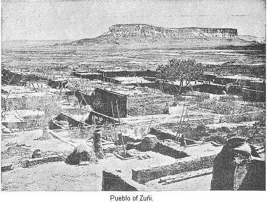
One of the most important pueblos yet remaining inhabited, and one of the first that Coronado encountered in his expedition, is Zuñi. The present pueblo is considered as the remaining one of the Seven Cities—at least, by the majority of Americanists. Whipple describes Zuñi as follows: "Treading an opening between rocky bluffs, . . . we entered the valley, several miles in width, which leads to Zuñi. The soil seemed light, but where cultivated it produced fine crops without the aid of irrigation. . . . Within the valley appeared occasional towers, where herders and, laborers watch to prevent a surprise from Apaches. Near the center of this apparent plain stood, upon an eminence, the compact city of Zuñi.3 By its side flowed the river which bears the same name. It is now but a rivulet of humble dimensions, though sometimes said to be a large stream. . . . Passing beneath an arch, we entered a court, . . . entirely surrounded by houses of several receding stories, which were attained by means of ladders loading from one to another. . . . From the top the pueblo reminds one of an immense ant-hill, from its similar form and dense population. . . . Going down from its outer side into the street, we encounter five stories of descent."4
In order to prevent confusion, we will state that a pueblo, which is the Spanish name for these old Indian towns, may be one of several different types. A common form of village consists of but one or two, seldom three, large buildings, so arranged as to surround an interior court. Sometimes there is but one large building, which is nearly in the shape of a half circle; instead of being really circular, it has a number of different sides. In some cases a village consists of a number of these large houses irregularly arranged. But the tendency is always to inclose a square.5
In the modern villages the buildings forming the square do not meet, but in some cases are connected by bridges or covered gangways, and in some instances the houses project over the streets below, which, being narrow, are thus given an underground appearance.6
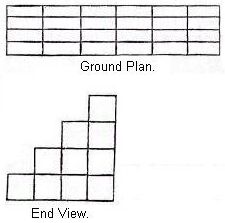 The buildings, or communal houses, for one house contained sometimes five hundred rooms, are generally from three to four hundred feet long and about one hundred and fifty feet in width at the base. The lower story is divided by cross-walls into a mass of cell-like rooms, as shown in the illustrations which represents the ground plan of a pueblo having four ranges of rooms. Each story in height has one less range of rooms, so that, looking directly at the end of this building, it would present the appearance shown by this cut: The only means of getting from one terrace to the other is by the aid of ladders. In some cases these terraces run from both sides of the building; in others they face the inclosed space; and in others still they face outside. Most of the inhabited pueblos are built of adobe—that is, sun-dried bricks. The majority of the ancient ruins were built of stone set in adobe mortar. With this digression, we will now return to Zuñi.
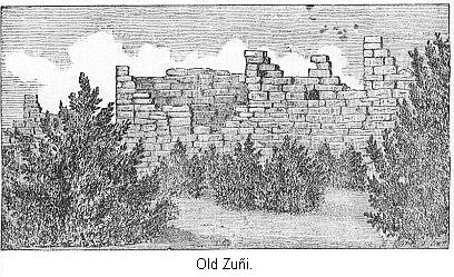
Ruins testifying to the former greatness of these people are scattered around them. Three miles to the east of the present pueblo of Zuñi, on the bluff seen in the cut, are the ruins of a larger pueblo, which is called Old Zuñi. Mr. Whipple, who explored this field of ruins, thus describes his visit: "The projecting summit of the cliffs seemed inaccessible. . . . We followed a trail which, with great labor, had been hammered out from seam to seam of the rocks along the side of the precipice. At various points of the ascent, where a projecting rock permitted, were barricades of stone walls, from which the old man7 told us they had hurled rocks upon the invading Spaniards. Having ascended one thousand feet, we found ourselves upon a level surface, covered with thick cedars. . . . The top of the mesa was of an irregular figure, a mile in width, bounded upon all sides by perpendicular bluffs. . . . The guide hurried us on half a mile further, where appeared the ruins of a city, indeed. Crumbling walls, from two to twelve feet in height, were crowded together in confused heaps, over several acres of ground. . . . Upon examining the pueblo, we found the standing walls rested upon ruins of greater antiquity.8 The primitive masonry, as well as we could judge, must have been about six feet thick. The more recent was not more than a foot or a foot and a half, but the small sandstone blocks had been laid in mud mortar with considerable care."9
The descriptions of ruins have so much that is similar that repetitions become tiresome. We will not, therefore, delay much longer with Zuñi. A few miles east of Old Zuñi we come to Pescado Springs, near which are the ruins of several pueblos. "This spring bursts from a broken point of the lava bed, and at once becomes a pretty stream, glittering with great numbers of the finny tribe, which gives name to it. The circular wall which once inclosed the fountainhead is now partly broken down. Upon each side, and almost tangent, are ruins of pueblos so ancient that the traditions of present races do not reach them. They are nearly circular in form, and of equal dimension. One measured three hundred and fifteen short paces, about eight hundred feet, in circumference. They were of stone; but the walls have crumbled, leaving only a heap of rubbish."10
Following up this stream, other ruins were found. It seems, then, that in the pueblo of Zuñi we have left a pitiful remnant of a numerous people. When the Spaniards first appeared on the scene they were apparently prosperous. The rapid decrease of the Pueblo tribes was owing to several causes. In 1680 they made an attempt to throw off the Spanish yoke. At first this was successful. But inter-tribal warfare at once set in. At this time also the inroads of the Apaches and Navajos became so troublesome that the Pueblo tribes could not successfully cultivate their land. At this time also a succession of dry years set in, and famine was the result. Their customs and manners we will describe in another place. There are many reasons for supposing that the country had been inhabited for a very long period, even before the Spaniards invaded it. Some places must have been even then in ruins, or, if inhabited, it is very strange that the Spanish records do not mention them. Such, for instance, is Inscription Rock, about fifteen miles east of Old Zuñi, which the Spaniards must have passed when on their way back and forth to Zuñi.
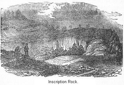
The small mesa here ends with a bold front of white sandstone rock, rising almost vertically two hundred and fifty feet high. This cut gives us a view on the top of the table-rock. We see here the foundations of two old buildings. A deep ravine nearly divides this little plateau into two portions. As we have said, this rises with a bold, precipitous front from the plain. At one place this front is completely covered with inscriptions. Here the Indians, unknown years ago, made their strange hieroglyphics which, presenting to our eyes only a senseless combination of forms of animals and men and meaningless figures, may have conveyed to them knowledge of important events. A great many Spanish inscriptions have also been carved on the rock. Whipple calls attention to the fact that though Spanish inscriptions placed there nearly two hundred years ago, seem but slightly affected by atmospheric action, still some of the Indian hieroglyphics are "almost wiped out by the fingers of time." A number of centuries have probably rolled away since they were inscribed.
It may be interesting to know the reading of some of these old inscriptions. A translation of one of the earliest and longest is here given, with the exception of a few words which could not be made out: "Bartolome Narrso, Governor and Captain-general of the province of New Mexico, for our lord, the king, passed by this place on his return from the pueblo of Zuñi, on the 29th of July, of the year 1620, and put them in peace, at their petition, asking the favor to become subjects of his majesty, and anew they gave obedience; all of which they did with free consent, knowing it prudent as well as very Christian, . . . to so distinguished and gallant a soldier, indomitable and famed; we love . . ."11
It is somewhat strange to meet thus in the interior of the United States with the record of a military expedition some months before the Puritans landed at Plymouth. There seems to be nothing especial to describe about the ruins. Both Simpson and Whipple notice that the masonry seems to be unusually good. As it must have been very difficult to procure water, the location must have been chosen solely for the protection it afforded. The early Spanish accounts contain the names of one hundred and twenty-six pueblos. Some are, however, mentioned two or three times. Mr. Bandelier has succeeded in identifying every one. The Rio Puerco Valley was never a very prosperous one, and the river is scarcely a permanent one. At present a few ruins at Poblazon, for instance, are to be seen, and the valley looks poor and barren.
The valley of the Rio Grande River was occupied by a number of Pueblo tribes, and there are at present eight inhabited pueblos along this river, in New Mexico, and one in Texas. The region around Bernalillo was a prosperous section. At intervals, up and down the river, and along its tributaries, we can still trace low crumbling ruins, evidence of an old pueblo. If the statements of the Spanish writers are to be believed, the number of inhabited towns, at the time of the conquest, was at least ten times that now existing. The population could never have exceeded forty thousand. At present it contains about nine thousand. Still making all allowance for Spanish exaggeration, we are convinced that it was a thickly populated country at the time of the conquest.
One of the most interesting pueblos in New Mexico is Jemez, on a river of that name, sixty miles west of Santa Fe. We speak of it here because it is the center of a most interesting group of ruins. Like the pueblo of Zuñi, it is a remnant only of a prosperous people. The reports of Coronado's expedition frequently mention Jemez, though it may be doubtful whether they refer to the pueblo of that name now, or to one of the numerous ruined ones in the immediate vicinity. Jemez is a prosperous pueblo, having fine fields, large irrigating ditches, and extensive flocks of sheep.
Simpson describes it in 1849 as follows: "The pueblo of Jemez is an Indian town of between four and five hundred inhabitants, . . . and is built upon two or three parallel streets, the houses being of adobe construction, and having second stories disposed retreatingly upon the first, to which access is had by means of ladders. . . . About the premises are probably a dozen acres covered with apricot and peach trees. . . . The Rio de Jemez, upon which the pave lies, is an affluent of the Rio Grande, varies from thirty to fifty feet in breadth, is of a rapid current. . . . Patches of good corn and wheat skirt it here and there along its banks, and the extent of cultivable land bordering it may be estimated at about a mile in breadth."
We are more interested, however, in ruins testifying to past greatness. "Six miles up the river you come to the union of two cañons—the Guadalupe and San Diego. Where the mesa between these cañons narrows itself to a point, are the ruins of two pueblos, one upon the lower prominence of the mesa, the other upon the mesa proper, and only approachable by two narrow, steep trails, the mesa everywhere else being nearly perpendicular, and seven hundred and fifty feet high. The view from the mesa is picturesque and imposing in the extreme. Far beneath, to the right and left, a stream makes its way between the colossal walls of the sandstone upon the narrow width of the mesa; near frightful precipices are the ruins of a town of eighty houses, partly in parallel rows, partly in squares, and partly perched between overhanging rocks, the rim and surfaces of which formed the walls of rooms, the gaps and interstices being filled in artificially."
"Nearly every house had one story and two rooms. The building material was trachytic rock as found upon the mesa. Broken pottery, charred corn, and millstones for grinding corn, were found in some of the rooms. The roofs had all fallen in, and so also had many of the side walls, in the construction of which wood was but little used. Piñon trees have taken root within many of the former rooms. Upon asking my Indian guide whether the former inhabitants of this town were obliged to descend the steep and dangerous pathway every day to the creek to procure water, he replied there were cisterns upon the mesa, in which rain, formerly plentiful, was caught. He then called my attention to some conical heaps of stones along the rim of the precipice which was the material for defense."12
This description introduces us to another class of ruins—that is, detached separate houses, different from the great communal structures we have already described. What connection exists between these two forms of houses will be studied in another place. As a rule, the rooms in the detached houses are larger than in the communal houses. Exceptions occur in some of the inhabited pueblos.13 This is only one of many towns in ruins thereabouts. According to Dr. Loew there are no less than twenty-five or thirty.
It is not our purpose to describe any more of the pueblos of this section of New Mexico than is required to enable us to understand the customs, manners, and habits of the Pueblo tribes. We learn that in New Mexico we are brought face to face with feeble remnants of former tribes, and that these were probably in their most flourishing condition when the Spaniards first invaded the country, and though in a few instances the ruins imply a great antiquity, as at Inscription Rock, still we may be reasonably sure that the majority of them date but a few centuries back. The ruins of Catholic churches established by the Franciscan monks in the sixteenth century occur in several places, five being found around Jemez.
The story of the decline of the Pueblo tribes may be illustrated by the history of Pecos. This pueblo was situated on the Rio Pecos, about twenty-five miles south-east of Santa Fe. With the exception of the present inhabited town of Taos, it was the most eastern point reached by the pueblo building tribes. This, though a very large pueblo, has nothing especial to attract attention, except that the entire mesa was inclosed by a stone wall about six feet and a half high, and twenty inches thick, having a total length of three thousand, two hundred and twenty feet.14 Its history is, however, interesting and instructive. Coronado, with his army, visited Pecos before he abandoned the country in 1543. His reports mention it as a prosperous pueblo. Several raids were made into New Mexico by Spanish parties, but the conquest proper occurred in 1598, when the Pecos pledged fidelity to the crown of Spain.
The Catholic Church at once set about establishing missions at various pueblos. The Pecos Church was established in 1629, though missionary work had been done here before that time. One of the priests who accompanied Coronado remained behind at Pecos. He was never afterwards heard from. This church became one of the most renowned in New Mexico. The inhabitants became herders as well as agriculturists. It was prosperous. In 1680 the Pueblo of Pecos sheltered two thousand Indians. "But a storm was brewing from whose effects the Pueblo tribes never recovered." In 1680 the Indians rose against the Spanish and drove them from New Mexico. The priests were murdered, the churches were sacked. From this time doubtless date the ruins of the churches seen around Jemez. At Pecos and many other places intertribal warfare set in. Bloody battles were fought.
Neither were the Spaniards idle. In 1682 one expedition was made, and at least two pueblo towns were destroyed by them. In 1689 the entire country was reconquered. Some tribes were nearly exterminated, and all more or less weakened and a great many ruins date from that time. It was the beginning of a decline for the Pueblo tribes, and this decline was hastened by intertribal warfare, by drought, and by ravages from wild Indians. As to the drought, it is sufficient to state that some ruins are now fifteen, and even twenty, miles from permanent water. The Comanches were the scourge of the Pecos. On one occasion they slaughtered all the young men but one. This was a blow from which they never recovered. Finally reduced by sickness to but five adults, the Pecos sold their lands and, at the invitation of their brethren at Jemez, went to live with them, and the pueblo of Pecos speedily became the ruins we now find it.15
No doubt a similar history could be written of many other ruins. "Our people," said Hosta, "were a warlike race, and had many fights, not only with the Spaniards, but also with other Indian tribes the Navajos and Taos, for instance and were thus reduced to this pueblo of Jemez, which now forms the last remnant." New Mexico is now becoming rapidly "Americanized," and it will soon be brought to a test whether the Pueblo tribes can withstand this new influence and retain their peculiar civilization, or whether, like many other races, their life force is nearly spent, in which case they will live only in history.
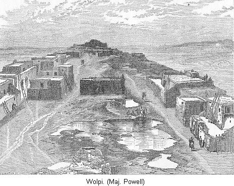
We must not overlook the Moki Pueblos in Arizona. They are situated one hundred miles northwest of Zuñi. The Spaniards discovered them, and called their province Tusayan. They are much like the Pueblo tribes of New Mexico, only they have been much less disturbed by outside influence. There are a number of ruined towns in this vicinity. We wish to refer to them because of their intimate connection with the ruins to the North. Their houses are built of stone on precipitous mesas.
Lieut. Ives, who visited them in 1858, has left quite a full description of them. He states that "each pueblo is built around a rectangular court, in which, we suppose, are the springs that furnished the supply to the reservoirs. The exterior walls, which are of stone, have no openings, and would have to be scaled or battered down before access could be gained to the interior. The successive stories are set back, one behind the other. The lower rooms are reached through trap-doors from the first landing. The houses are three rooms deep, and open upon the interior court."16 He was much pleased with the manner in which they had terraced off the bluff of the mesas into little garden patches, irrigating them from the large reservoirs from the top.
There is one feature common to all the Pueblo tribes which is necessary to refer to here, from its connection with the ruined structures further north. In all of the inhabited pueblos there is a structure known as an Estafa, some pueblos having several. They are usually circular, but occasionally (as at Jemez) rectangular. They are generally subterranean, or mostly so. They are great institutions among the Pueblos. "In these subterranean temples the old men met in secret council, or assembled in worship of their gods. Here are held dances, festivities, and social intercourse."
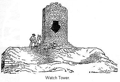
Another common feature, represented in this cut, is the watch-tower. It is either round, as in this case, or rectangular. It may be interesting to recall in this connection the signal mounds of the Mound Builders. They were not always in the immediate vicinity of other ruins. Neither can we state that there was a system in their arrangement, one answering to another at a distance, and yet it was noticed where the rains were numerous that several were in view from one point.17 In dimensions these towers range from ten to fifteen feet in diameter, and from five to fifteen feet in height, while the walls are from one to two feet thick. They are in many cases connected with structures rectangular in form.
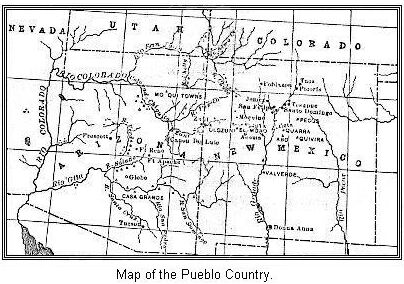
We will now leave the inhabited pueblos and the ruins in their immediate vicinity and, going to the north, explore a section of country that shows every evidence of having sustained a considerable population some time in the past. To understand this fact clearly, it will be necessary to fix the location of the places named by means of the map. From time to time confused reports of the wonders to be seen in the San Juan section of Colorado had appeared in the East, but the first clear and satisfactory account is contained in the reports of Messrs. Jackson and Holmes, members of the U.S. Geographical and Geological survey of the territories under Dr. Hayden for 1874 and 1876.
In the south-western portion of Colorado is a range of mountains known as the San Juan. Stretching from their base west to the Sierras is a great plateau region, drained by the numerous tributaries of the San Juan River. It would, perhaps, be more in keeping with the facts of the case to say "had been drained some time in the past," for this is now such an arid, semi-desert country that the majority of the streams are dry, or have but scattered pools of water in them, during a large portion of the year; and yet, at times, great volumes of water go sweeping through them. This whole plateau is cut up with long, cañoned valleys, presenting, in effect, the same surface features that we have already described in New Mexico. Yet this precipitous, cañon-marked section of country is literally filled with the crumbling ruins of a former people. The situation in which they occur is in many cases very singular, and the whole subject is invested with great interest to us, because we see in them the remains of a people evidently the same as the Pueblo people to-day.
One of the most extensive ruins in this section is situated at Aztec Springs. This, it will be seen, is about midway between the Rio Mancos and the McElmo. Mr. Holmes found the site of the spring, but it contained no water. He was told, however, by those familiar with the locality that there had been a living spring there up to within a few years. It was evidently a place of considerable importance once. Mr. Holmes describes the ruins as forming the most imposing pile of masonry found in Colorado. They cover an area of over ten acres. This includes only the ruins around the springs. But all about this central portion are scattered and grouped the remnants of smaller structures. So that nearly a square mile is covered with the ruins of this ancient pueblo. Most of the stone used was brought from the Mesa Verde (Green Plateau), a mile away, and must have been a great work for a people so totally without facilities.
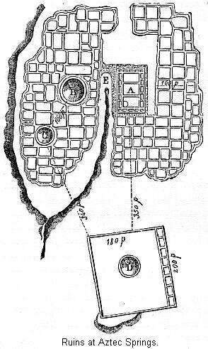 It will be seen that immediately to the right of the Springs is a large rectangular ruin in better preservation than the rest. This now "forms a great mound of crumbling rock from twelve to twenty feet in height, overgrown with artemisia, but showing clearly, however, its rectangular structure, adjusted approximately to the four points of the compass." This house, from its massive walls, must have had an original height of at least forty feet. "The walls seem to have been doubled, with a space of seven feet between; a number of cross-walls at regular intervals indicate that this space has been divided into apartments, as seen in the plan." Two low lines of rubbish cross the square, probably partition walls.
Surrounding this house is a net-work of fallen walls, so completely reduced that none of the stones seem to remain in place. Mr. Holmes was at a loss to know whether to call them a cluster of irregular apartments, having low, loosely built walls, or whether they are the remains of imposing pueblos. In the group of ruins to the left of the spring are two well-defined circular estufas. Below the main mass of ruins, connected by low walls of ruins, is another great square, nearly two hundred feet in dimensions. One wall seems to have consisted of a row of apartments; the other walls served to simply inclose the square, near the center of which was another large estufa.
Several important conclusions can be drawn from a study of this locality. The spring, now dry, was once evidently the source of a considerable stream. Whether the group of low ruins were collections of small houses, or remains of imposing pueblos, we need not doubt that the walls of the square inclosures were composed of pueblo houses. The estufas were probably in all respects similar to those of the present inhabited pueblos. The country around, now so dry and barren, must once have supported considerable population. As to the period of abandonment, we have nothing to guide us. Being an agricultural settlement, it was probably abandoned at an earlier date than the cave-dwellings and cliff-houses of the cañons of the vicinity. The reason for this will appear subsequently. The site of this ruin, as well as for a long distance around, is covered with pieces of broken pottery. We notice that the spring has only lately gone dry. This illustrates the changes now taking place all through the country. It is drying up, and this process has been in operation for a long while.
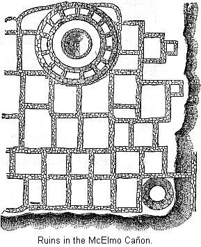 Many groups of ruins are now in localities where the people could not hope for subsistence. About six miles to the north of these ruins, about a mile from the McElmo, is the group of ruins here represented, which may throw some light on the remains at Aztec Springs. The principal feature is the triple walled tower, of which a plan is given. The tower has a diameter of about forty-three feet, and a circumference of about one hundred and thirty-five feet. The walls are traceable nearly all the way around, and the space between the two outer ones, which is about five feet, contains fourteen apartments or cells. The walls about one of these cells were still standing at the time of Mr. Holmes's visit, but the cell was filled with rubbish from the fallen walls. A door-way, opening into this apartment, could still be seen. The inner wall was probably never very high. It simply inclosed the estufa.
The ruins surrounding this tower consist of low, fallen walls, scarcely traceable. The apartments number nearly one hundred, and were generally rectangular. They are not of a uniform size, and were certainly not arranged in regular order. Now, as Mr. Holmes observes, it would certainly seem that, if they are the ruins of such structures as the pueblos of the south, there would be some regularity of size, and some systematic arrangement. He says that, in reality, they are more like a cluster of pens, such as are used by the Moqui tribes for keeping sheep and goats.
Since these surveys were made, Mr. Bandelier, as agent for the Archæological Institute, has made important researches. He finds that the small, detached houses, such as we described in the ruined village near Jemez, are found in Arizona, with a small court-yard or inclosure attached to them. If we understand the description of the ruins just mentioned, and those at Apache Springs, they are villages of these small houses and their inclosures. In such villages the inclosures meet each other, so as to form a checker-board of irregularly alternating houses and courts. The houses are easily discernible from the fact of little rubbish mounds having accumulated where they stood. Around these parts of the wall can still be traced. This combination makes a strong, easily defended position. Each of such villages contains one or more open spaces of large size, but they are irregularly located.
We must notice one point more: Each village of this nature, that was of any size, contained a larger ruin in the center. This was noticed in the ruins at Aztec Springs. This larger building was in the nature of a citadel, and there the inhabitants could retire when the approaches were carried by the enemy. This central building ultimately swallowed up all the others, and so developed into the pueblo structures we have noticed. The little walled inclosures surrounding the houses were largely in the nature of defenses. Tradition asserts that in many cases they were garden plats, and appearances sometimes confirm this. "They may also have been the yard proper for each family, in which the latter slept, cooked—in fact, lived—during the heat of the Summer months."18
Referring once more to the ruins near the McElmo, we are told that every isolated rock and bit of mesa within a circle of miles of this place is strewn with remnants of ancient dwellings. We presume these were small, separate houses. They may have been outlying settlements of the tribe whose main village was at Aztec Springs. We must also notice the small tower in the corner. This was a watch tower. It was fifteen feet in diameter, walls three and a half feet thick, and in 1876 was still five feet high, It overlooked the surrounding country. The rainfall in the past must have been more abundant, to support the population we are justified in thinking once lived there. The nearest water is now a mile away, and during the dry season some fifteen miles to the north, in the Rio Dolores, and yet we have every reason to believe these old inhabitants were very saving of water. They built cisterns and reservoirs to store it up against the time of need.
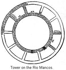 We give a cut of the tower of the ruins of a similar village, or settlement, to the one just described, which occurs twenty miles to the southeast in the cañon of the Rio Mancos. Being so similar, we will mention it here. In this case the tower had only two walls. Mr. Holmes says the diameter of the outer wall is forty-three feet, that of the inner twenty-five feet. The space between the two circles is divided by cross-walls into ten apartments. This tower is placed also in the midst of a group of more dimly marked ruins or foundations, extending some distance in each direction from it. Mr. Holmes, however, states that there are no ruins of importance in connection with this tower, but that there are a number of ruins in the immediate vicinity. In this case, then, the citadel (if such it was) was not directly connected with other ruins.
The Rio Mancos, that we have just mentioned, was a favorite place of resort for these old people. This stream, rising in the La Platte Mountains, flows through beautiful valleys to a great table-land known as the Mesa Verde. Mr. Jackson explored this valley in 1874, and he reports as follows: "Commencing our observation in the park-like valley of the Mancos, between the mesa and the mountains, we find that the low benches which border the stream upon either side bear faint vestiges of having at some far away time been covered with dwellings, grouped in communities apparently, but so indistinct as to present to the eye little more than unintelligible mounds. By a little careful investigation, however, the foundation of great square blocks of single buildings and of circular inclosures can be made out, the latter generally of a depressed center, showing an excavation for some purpose."
From this description we can not quite make out whether these ruins are great communal buildings, like the modern pueblo, or clusters of separate houses. We incline to the latter opinion, however. The circular depressed area was doubtless used as an Estufa, the place of religious meetings for men alone. "The greater portion of these mounds are now overgrown with artemisia, pinion-pine, and cedar, concealing them almost entirely from casual observation." "We found the surest indication of their proximity in the great quantity of broken pottery which covered the ground in their neighborhood. The same curiously indented, painted, and glazed ware, was found throughout New Mexico and Arizona. It was all broken into very small pieces, none that we could find being larger than a silver dollar." Specimens of this pottery will be figured in its appropriate place.
"Nowhere among these open plane habitations could we discover any vestige of stone-work, either in building material or implements. It is very evident that the houses were all of adobe, the mound-like character of the remains justifying that belief." In this last respect we note a difference between these remains and those already described. The mesa verde is one of those elevated plateaus we have so often described. Through this the Mancos has cut a cañon nearly thirty miles in length, and from one to two thousand feet deep. The description we have already given is of the valley of the river before coming to the cañon.
Entering the cañon, Mr. Jackson continues: "Grouped along in clusters, and singly, were indications of former habitations, very nearly obliterated, and consisting mostly, in the first four or five miles, of the same mound-like forms noticed above, and accompanied always by the scattered, broken pottery. Among them we find one building of squared and carefully laid sandstone, one face only exposed of three or four courses, above the mass of debris which covered every thing. This building lay within a few yards of the banks of the stream, was apparently about ten feet by eight, the usual size, as near as we could determine, of nearly all the separate rooms or houses in the larger blocks, none larger, and many not more than five feet square. The stones exposed are each about seven by twelve inches square, and four inches thick, those in their original position retaining correct angles, but, when thrown down, worn away by attrition to shapeless bowlders."
"As we progressed down the cañon the same general characteristics held good. The great majority of the ruins consisting of heaps of debris a central mass considerably higher and more massive than the surrounding lines of sub-divided squares. Small buildings, not more than eight feet square, were often found standing alone apparently, no trace of any other being detected in their immediate neighborhood." We would call especial attention in this description to the character of the ruins, the central, higher mass surrounded by other ruins; also to the houses found occasionally standing alone. We notice they are of the same general character as the ruins at Aztec Springs.
We are finding abundant evidence that this section was once thickly settled. Going back to the triple-walled tower on the McElmo, Mr. Jackson says of the immediate vicinity: "On the mesa is group after group upon the same general plan, a great central tower and smaller surrounding buildings. They cover the whole breadth and length of the land, and, turn which way we would, we stumbled over the old mound and into the cellars, as we might call them, of these truly aborigines." We believe, however, that no excavation for cellar purposes are found in the entire region covered by these ancient ruins.
"Starting down the cañon (the McElmo), which gradually deepened as the table-land rose above us, we found upon either hand very old and faint vestiges of the homes of a forgotten people, but could give them no more attention than merely noting their existence."
Mr. Morgan has shown the existence of regular large houses in the valley of Aminas River, east of the Mancos;19 and he also speaks of the ruins at the commencement of McElmo cañon as being large communal buildings. We should judge from Mr. Jackson's report just given that these ruins were rather small clusters of houses of the same design as the ruins at Apache Springs.
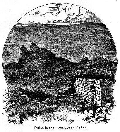
Near the Utah boundary line we notice the Hovenweep Creek joining the McElmo from the north. The mesa, narrowing to a point where the two cañons meet, is covered with ruins much like what we have described already. The Hovenweep is appropriately named, meaning "deserted valley."
Further west still is the Montezuma Valley. Mr. Jackson's party found the ruins so numerous as to excite surprise at the numbers this narrow valley must have supported. He says, "We camped at the intersection of a large cañon coming in from the west. . . . At this point the bottoms widen out to from two to three hundred yards in width, and are literally covered with ruins, evidently those of an extensive settlement or community, although at the present time water was so scarce (there not being a drop within a radius of six miles) that we were compelled to make a dry camp. The ruins consist evidently of great solid mounds of rock debris, piled up in rectangular masses, covered with earth and a brush growth, bearing every indication of extreme age—just how old is about as impossible to tell as to say how old the rocks of this cañon are. This group is a mile in length, in the middle of the valley space, and upon both sides of the wash. Each separate building would cover a space, generally, of one hundred feet square; they are seldom subdivided into more than two or four apartments. Relics were abundant, broken pottery and arrow-points being especially plenty. At one place, where the wash held partially undermined the foundation of ore of the large buildings, it exposed a wall of regularly laid masonry, extending down six feet beneath the superincumbent rubbish to the old floor-level, covered with ashes and the remains of half-charred sticks of juniper."
Lower down, the valley was noted for little projecting tongues of rock extending out into the cañon, sometimes connected with the main walls of the cañon by narrow ledges of rock, and in cases even this had disappeared, leaving detached masses of rock standing quite alone. "Within a distance of fifteen miles there are some sixteen or eighteen of these promontories and isolated mesas of different height, every one of them covered with ruins of old and massive stone-built structures."
We have been somewhat full in our description of these ruins, yet their importance justifies this course. So far we see but very little to remind us of the pueblo towns. On the other hand, the buildings seem to be often single houses, or a few houses grouped together. In some locations they were built of stone, in others of adobe. It is to be observed, however, that the houses are very small—not larger than the rooms in the modern pueblos. We evidently have here quiet scenes of agricultural life. They of course had enemies, and guarded against their attacks by the watch-towers, of which an example is given in the McElmo ruins. The country must have been better watered than now, the soil productive the seasons kind; and who can tell how long these agricultural tribes held the land? Under these conditions, time must have been rapidly bringing them civilization. But we must now turn to a sorrowful chapter in their history, and trace the dispersion of these tribes, their unavailing attempts to hold their own against a savage foe, and the desperate chances they took before leaving the land of their fathers.
This brings us to a consideration of cliff-houses—that is, houses so placed that manifestly the only reason the people would have for putting them where found would be of a defensive nature; and, for a similar reason, we may be very sure they are of a later date than the majority of the ruins in the valley or in the cañons. People would never have settled in the valley in the first place if they had felt the necessity of seeking inaccessible places in which to build shelters as a resort in time of need. We can not do better than to refer once more to Mr. Jackson's exploration in the valley of the Rio Mancos. We have already referred to it in reference to the larger ruins.
This cut gives us a general view of the first cliff-house discovered in this valley. This was far up on the cliff. Mr. Jackson says, "We had no field-glass with the party, and to this fact is probably due the reason we had not seen others during the day in this same line, for there is no doubt that ruins exist throughout the entire length of the cañon, far above and out of the way of ordinary observation." Subsequently Mr. Holmes proved this supposition to be true. The sides of this cañon have nearly all their ledges occupied by these houses.
Every advantage was taken, both natural and artificial, to conceal them from view. "Cedars and pines grew thickly along the ledges upon which they are built, hiding completely any thing behind them. All that we did find were built of the same materials as the cliffs themselves with but few, and then only the smallest, appertures toward the cañon, the surface being dressed very smooth, and showing no lines of masonry. It was only on the very closest inspection that the houses could be separated from the cliff."
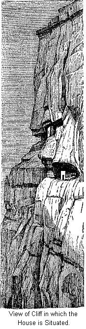 To illustrate the singular position in which this house was located, we introduce this cut. It is seven hundred feet above the valley. "Whether viewed from below or from the heights above, the effect is almost startling, and one can not but feel that no ordinary circumstances could have driven a people to such places of resort." As showing the difficulty an enemy would have to approach such a house, we give Mr. Jackson's account of his climb to it:
"The first five hundred feet of ascent were over a long, steep slope of debris, overgrown with cedar, then came alternately perpendiculars and slopes. Immediately below the house was a nearly perpendicular ascent of one hundred feet, that puzzled us for a while, and which we were only able to surmount by finding cracks and crevices into which fingers and toes could be inserted. From the little ledges occasionally found, and by stepping upon each other's shoulders, and grasping tufts of yucca, one would draw himself up to another shelf, and then, by letting down a stick of cedar or a hand, would assist the others."
"Soon we reached a slope, smooth and steep, in which there had been cut a series of steps, now weathered away into a series of undulating hummocks, by which it was easy to ascend, and without them almost an impossibility. Another short, steep slope, and we were under the ledge on which stood our house." By referring to the first cut, we see that the house stands on a very narrow ledge, and that the rocks overhang it so as to furnish a roof. It will also be noticed that the ledge is rounding, so that the outer walls of the house rise from an incline. Piers, or abutments, had also been built along the ledge, so as to form an esplanade.
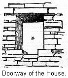 The house itself was only about twelve feet high, but this had been divided into two stories. Whether it ever had any other roof than the overhanging walls of rock is doubtful. The plan is shown in the preceding cut. The curved apartment at the right is a reservoir, capable of holding about five barrels. A series of pegs were inserted in the wall, so as to form a means of descent from a window to the bottom. A number of doorways are seen in the plan; a cut of one is presented in this figure.
We are, however, warned that the artist has represented the stonework a little too regularly. The support for the top of the doorway is not clearly shown; a number of small beams of wood were laid across, on these the stones. This cut gives us a view of the front room. Looking in from the end window, we can see where the second story commenced. The doorway we have been describing was not a very handy mode of entrance. Its builders, however, did the best they could in their limited space. The house displays perseverance, ingenuity, and taste. It was plastered, both within and without, so as to resemble the walls of the cañon, but an ornamental border was added to the plastering of the interior rooms.
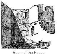 This cliff house could only have been used as a place of refuge in a time of need. We must observe the care with which it was hidden away. The walls were plastered on the outside, so as to resemble the cañon-walls. Then we must notice what a secure place of retreat it afforded the people. No invading party could hope to storm this castle as long as there was any one to defend it. This house, with its four small rooms, could give shelter to quite a band of Indians. Then, besides, it was not alone. Ruins of half a dozen smaller houses were found near by. Some had been crushed by the overhanging walls falling upon them, and others had lost their foothold and tumbled down the precipice.
It needs but a glance to satisfy any one that only dire necessity would have driven a people to such resorts. When we consider how much labor it must have required to convey the materials to the almost inaccessible place, the many inconveniences the people must have been put to when they were occupied, we may imagine how the people clung to their old home. It is altogether likely that such resorts would be only used now and then. During seasons of war and invasion probably the women and old the men, with the little ones, went thither for protection.
Mr. Holmes calls attention to one point bearing on the antiquity of this ruin. The buttresses, which probably support a balustrade, noticed in the figure on the house, were built on the sloping surface of the rock. It would take but very little weathering of the rocks to throw them to the bottom of the cañon; and, furthermore, the rock is a rough sandstone, and hence easily crumbles; and it is not well protected by the overhanging cliff; but no perceptible change has taken place since the buttresses were first built. The thickness of a sheet of paper has hardly been washed from the surface, and the mortar, almost as hard as the rock itself, lies upon it as if placed there within a dozen years. This structure is, evidently, not as old as the low mounds of crumbling ruins we have heretofore described. It is more than probable that such retreats as this were not provided until near the close of their stay in the country.
A ruin further down the cañon, described by Mr. Holmes, is of great interest, as it shows how necessary the people considered it to be to construct an estufa. It will be observed that there are two houses. So nicely are these hidden away that Mr. Holmes had almost completed a sketch of the upper house before he noticed the lower one. They are both overhung by the rocks above so as to be protected from the weather. The upper house can only be approached by means of steps cut in the rock. It appears to be in an unfinished state, and, when we consider the great labor required for its construction, we can not wonder that they grew tired before its completion.
The lower house is some eight hundred feet above the bottom of the cañon, but is comparatively easy of approach. The interesting feature about it is the estufa. It was situated near the center of the main portion of the house. The entrance to this chamber shows the peculiar importance attached to it by the builders. Mr. Holmes says: "A walled and covered passage-way of solid masonry, ten feet of which is still intact, leads from an outer chamber through the small intervening apartments into the circular one. It is possible that this originally extended to the outer wall, and was entered from the outside. If so, the person desiring to visit the estufa would have to enter the aperture about twenty-two inches high by thirty wide, and crawl, in the the most abject manner possible, through a tube-like passage-way nearly twenty feet in length."
"My first impression was that this peculiarly constructed way was a precaution against enemies, and that it was probably the only means of entrance to the interior of the house, but I am now inclined to think this is hardly probable, and conclude that this was rather designed to render a sacred chamber as free as possible from profane intrusion." This illustrates the peculiar regard in which it was held. Even when sore pressed by their enemies, and obliged to flee to inaccessible heights, they still constructed their sacred place.
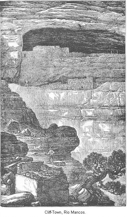
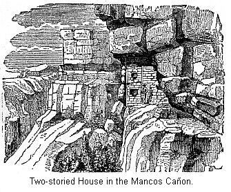
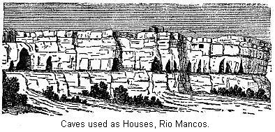
These cliff-houses, of which we give illustrations, are quite common in the Mancos. Our frontispiece shows an interesting group, about ten miles from the foot of the cañon. These are situated only about forty feet above the bed of the creek, but still in a secure position. Here a bed of shale had been weathered out of the sandstone, leaving a sort of horizontal groove four feet high and from four to six feet deep. In this a row of minute houses had been built. They had been made to occupy the full height and depth of the crevice, so that when one reaches it at the only accessible point he is between two houses, and must pass through these to get at the others.
Besides the cliff-houses, the explorers found that these people had made use of little cave-like openings in the cliffs, and, by walling up the openings, had converted them into houses. These were very common in the Mancos, and of all sizes. Some were evidently merely little hiding places, in which to store away provisions or other articles. In some places the cliffs were literally honey-combed with these little habitations. Sometimes the walls were quite well preserved and new-looking, while all about were others in all stages of decay.
"In one place in particular a picturesque outstanding promontory has been full of dwellings. . . . As one from below views the ragged, window-pierced crags, he is unconsciously led to wonder if they are not the ruins of some ancient castle, behind whose mouldering walls are hidden the dread secrets of a long-forgotten people; but a nearer approach quickly dispels such fancies, for the windows prove to be only the doorways to shallow and irregular apartments hardly sufficiently commodious for a race of pigmies. Neither the outer openings nor the apertures that communicate between the caves are large enough to allow a person of large stature to pass, and one is led to suspect that these nests were not the dwellings proper of these people, but occasional resorts for women and children, and that the somewhat extensive ruins of the valley below were their ordinary dwelling places."20
On the San Juan, about ten miles above the mouth of the Mancos, is a significant combination of cave-dwellings and towers. In this case, about half-way up the cliff, which is not more than forty feet high, excavations had been made in a soft bed of shale. They are now quite shallow, but were probably once deeper and walled up in front. Directly above these cave-openings, on the very brink of the cliffs, were the remains of two circular towers, in each case double-walled, and probably divided by cross-walls into partitions. The towers were probably their council chambers and places of worship. The caves, directly below, down a steep bank, were their fortresses, whither in times of danger they could flee. The little community, by means of ladders, could freely pass from their cave resorts to the towers and back.
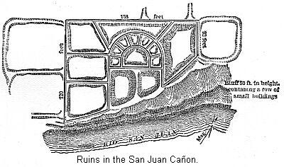
The San Juan River does not seem to be as rich in ruins as some of its tributaries. Yet near the mouth of the Montezuma we came upon a ruin which shows considerable analogy to the pueblos. Mr. Jackson says upon the top of the bench (fifty feet high) overlooking the river are the ruins of a quadrangular structure of a peculiar design. It is arranged very nearly at right angles to the river. We see from the plan that we have the ruins of a larger building arranged around an open court—at least, Mr. Jackson could detect no trace of a wall in front. We must notice the seven apartments, arranged in the form of a semicircle, back of the court. Extreme massiveness is indicated throughout the whole structure.
In the immediate vicinity of this ruin were found a number of little, cave-like dwellings. They were so small that doubts were raised as to whether they were suitable for human habitations, but the majority of them bore ample evidence in smoke-begrimed walls that such was their use. Twelve miles below the mouth of the Montezuma this group of ruins was discovered. These were situated in a cave that was almost exactly a hemisphere in shape. Where the curve of the roof met the curve from the bottom a little projecting bench had been utilized as a foundation for a row of houses.
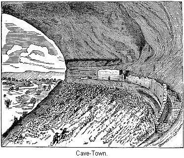
The little community that built their houses here seem to have practised all the industries of a savage life. In one place there was evidence that on that spot had been carried on the manufacture of stone implements. At another place holes had been drilled, as if for a loom. In the main building there were fourteen rooms or apartments, ranging from sixteen to nine feet in width. "In the central room of the main building we found a circular, basin-like depression, that had served as a fireplace, being still filled with the ashes and cinders of aboriginal fires, the surrounding walls being blackened with smoke and soot. This room was undoubtedly the kitchen of the house. Some of the smaller rooms appear to have been used for the same purpose, the fires having been made in the corner against the back wall, the smoke escaping overhead. The masonry displayed in the construction of the walls is very creditable. A symmetrical curve is preserved throughout the whole line, and every portion perfectly plumb. The subdivisions are at right angles to the front. The whole appearance of the place and its surroundings indicate that the family or little community who inhabited it were in good circumstances, and the lords of the surrounding country. Looking out from one of their houses, with a great dome of solid rock overhead that echoed and re-echoed every word uttered with marvelous distinctness, and below them a steep descent of one hundred feet to the broad, fertile valley of the Rio San Juan, covered with waving fields of maize and scattered groves of majestic cotton-woods, these old people, whom even the imagination can hardly clothe with reality, must have felt a sense of security that even the incursions of their barbarian foes could hardly have disturbed."21
To describe the defensive ruins on Epsom Creek, Montezuma Creek, and the McElmo is simply to repeat descriptions already given. We meet with cave-houses, cliff-houses, and sentinel-towers in abundance. The whole section appears to have been thickly settled. Further explorations will doubtless make known many more ruins, but probably nothing differing in kind from what is already known. We think the defensive ruins belong to a later period of their existence than do the old and time-worn structures we have hitherto described along the river valleys and open plains, as at Aztec Springs. These structures plainly show that at the time they were built the people were subject to an invasion from a stronger foe, one before whose approach they had to fly for protection to the almost inaccessible cliffs.
They would obviously never have settled there had they always had to contend with these savage tribes. It needs no great skill to read the story of the dispersion of these old people from the ruins we have described; the many watch-towers, which were also used as fortresses or citadels in which to find protection, testifying to the need of increased watchfulness. The cave- houses and cliff-fortresses, cunningly hidden away to escape detection, or so placed as to defy the assault of their enemies, show to what desperate straits they were driven; and imagination only can picture the despair that must have filled their hearts when the hour of final defeat came, and they must have realized that even these shifts would not allow them to stay in the lands of their fathers.
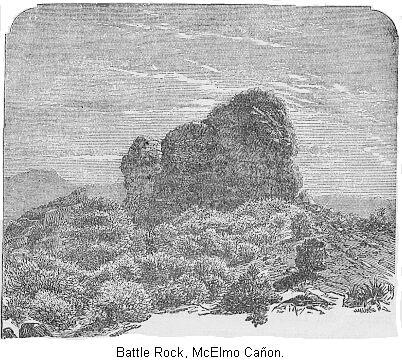
That this is the explanation of these ruins, we will cite the legendary stories given by an old man among the Moquis concerning some ruins in the cañon of the McElmo, just over the line in Utah. At this point the cañon widens out considerably, and in the center of the valley is still standing a portion of the old mesa, once filling the entire valley. It is now a mass of dark red sandstone, about one hundred feet high, and three hundred feet around, seamed and cracked, and gradually disappearing, as the rock has gone all around it. The top of this rock is covered with the ruins of some building; there are also ruins at the base and all around the immediate vicinity. There were watch towers and estufas, showing that this was a place of great interest.
The story is as follows: "Formerly the aborigines inhabited all this country as far east as the headwaters of the San Juan, as far north as the Rio Dolores, west some distance into Utah, and south and south-west throughout Arizona, and on down into Mexico. They had lived there from time immemorial, since the earth was a small island, which augmented as its inhabitants multiplied. They cultivated the valley, fashioned whatever utensils and tools they needed very neatly and handsomely out of clay, and wood, and stone, not knowing any of the useful metals; built their homes and kept their flocks and herds in the fertile river bottoms, and worshiped the sun. They were an eminently peaceful and prosperous people, living by agriculture rather than by the chase. About a thousand years ago, however, they were visited by savage strangers from the north, whom they treated hospitably. Soon these visits became more frequent and annoying. Then their troublesome neighbors, ancestors of the present Utes, began to forage upon them, and at last to massacre them and devastate their farms. So, to save their lives at least, they built houses high up on the cliffs, where they could store food and hide away until the raiders left.
"But one Summer the invaders did not go back to their mountains, as the people expected, but brought their families with them and settled down. So, driven from their homes and lands, starving in their little niches on the high cites they could only steal away during the night and wander across the cheerless uplands. To one who has traveled these steppes such a flight seems terrible, and the mind hesitates to picture the sufferings of the sad fugitives. At the 'Creston' (name of the ruin) they halted, and probably found friends, for the rocks and caves are full of the nests of these human wrens and swallows. Here they collected, erected stone fortifications and watch-towers, dug reservoirs in the rocks to hold a supply of water, which in all cases is precarious in this latitude, and once more stood at bay. Their foes came, and for one long month fought, and were beaten back, and returned day after day to the attack as merciless and inevitable as the tide. Meanwhile the families of the defenders were evacuating and moving south, and bravely did their defenders shield them till they were all safely a hundred miles away.
"The besiegers were beaten back and went away. But the narrative tells us that the hollows of the rocks were filled to the brim with the mingled blood of conquerors and, conquered, and red veins of it ran down the cañon. It was such a victory as they could not afford to gain again, and they were glad, when the long flight was over, to follow their wives and little ones to the south. There, in the deserts of Arizona, on well-nigh unapproachable, isolated bluffs, they built new towns, and their few descendants, the Moquis, live in them to this day, preserving more carefully and purely the history and veneration of their forefathers than their skill or wisdom."22
Mr. Jackson thinks this legend arises from the appearance of the rocks. The bare floor of nearly white sandstone, upon which the butte stands, is stained in gory streaks and blotches by the action of an iron constituent in the rocks of another portion of the adjoining bluffs. That may well be true, but we believe that there are germs of truth in the story. Driven from their homes, where did the fugitives go? Some of them may have gone east, but probably the body of the migration was to the south. It has been the tendency of all tribes, but especially of the sedentary tribes, to pass to the south and east, and this is also the traditions among the inhabitants of still existing pueblos.23 We find that every available portion of New Mexico and Arizona bears evidence of having been once populated by tribes of Indians, who built houses in all respects like those already described. In northern New Mexico, Prof. Cope has described a whole section of country as being at one time more densely populated than the thickly inhabited portions of the Eastern States. He says: "The number of buildings in a square mile of that region is equal to, if not greater than the number now existing in the more densely populated rural districts of Pennsylvania and New Jersey."24
In one location he found a village of thirty houses, built of stone, and all in ruins. He found, over a large extent of country, that every little conical hill and eminence was crowned with ruins of old houses. We, of course, can not say that these ruins are necessarily younger than those to the north of the San Juan, and yet we think from Prof. Cope's description that they do not present such evidence of antiquity as do the crumbling ruins previously described. And then, besides, they were always located in easily defended positions.
The village spoken of was really a Cliff Village, being arranged along the very edge of a precipitous mesa, the only access to it being along a narrow causeway. Then again, although we have described many ruins near which no water is to be had, at least, in dry seasons, yet we have every reason to suppose water was formerly more plentiful and easily attained. But in this section it must always have been a serious question with them to obtain enough water for necessary purposes. They must have had to store away water in vessels of pottery, whose ruins are now so abundant. It is not such a country as we would suppose a people to choose for a place to settle in, only that they knew not where else to go.
It is also considered settled that all the inhabited pueblos, as well as those in ruins near the inhabited ones, were built by the descendants of these people whose houses we have described. This is proven by the similarity of pottery. Though some styles of ancient corrugated ware are found in the San Juan section not found near the inhabited pueblos, yet vast quantities of ware, similar to that now found in the inhabited pueblos, can be picked up all over the ruins to the north. Again, their religion must have been the same, as ruined estufas are common, in all respects similar to those now in use. In the modern pueblos we are struck with the small cell-like rooms, yet they are but little smaller than the ordinary single houses plentifully found over the entire field of ruins. All the Pueblo tribes are agricultural, so were these old people. In fact, all evidence confirms the conclusion that the remnants of the Pueblo people that we have already described, are also the descendants of the people driven by hostile bands from north of the San Juan.
This statement may give false impressions, however. The traditions of the Pueblo Indians, of New Mexico, are to the effect that they came from the north, and also that their ancestors formerly lived in the small houses we have described. But we do not mean to say that all the small houses and pueblos in Arizona and New Mexico are later in date than the cliff-houses. The pressure has always been from the north to the south. Neither would we be understood as saying that all the sedentary tribes, both ancient and modern, belong to the same stock of people. There are several different stocks of people even among the present Pueblos.25
In the valley of the Rio Chaco, about midway between the Rio Grande and the San Juan, we meet a group of ruined pueblos whose style of masonry is thought to indicate a greater antiquity than the inhabited pueblo towns; these probably indicate another settlement of these people. As these are really remarkable ruins, we must briefly describe them. In the Chaco cañon, as indicated on the map, within the space of ten miles are the ruins of eight larger pueblos. Another is located at the very beginning of the cañon, and two more on the edge of the mesas just outside of the cañon. These are large communal houses of regular pueblo type, and, theoretically at least, they should be later in date than the majority of ruins throughout the area represented on the map. We think the development has been from small, separate houses, to a closely connected cluster, with a central citadel, which finally drew to itself all the other buildings, and became the communal building we call a pueblo.26
We give a restoration of, one—the Pueble Bonito—one of the largest and most important of the ruins. We can not doubt but what the restoration is substantially correct. It shows the open court, the terraced structure, and the system of defense. The circle itself is not as near a half-circle as we would imagine. The ground plan shows that it was really a many-sided building. This pueblo must have presented a striking appearance when it was in a complete state.
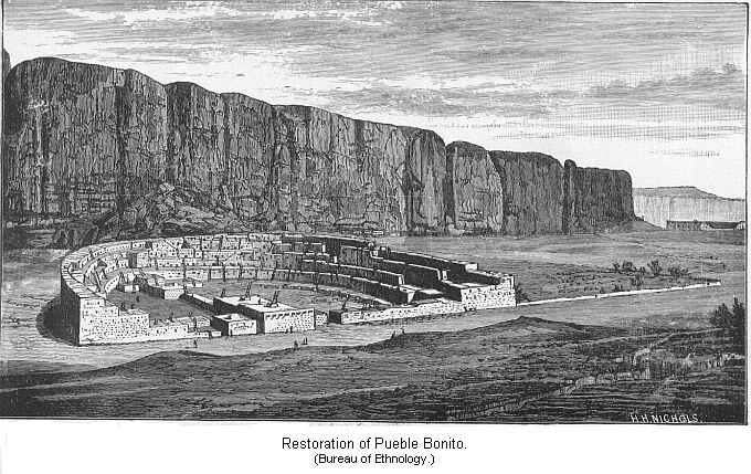
By comparing this structure with the views of some of the present pueblo towns, we will understand the remarks made earlier, as to the different styles of pueblo structures. This building must have had not far from six hundred and fifty rooms. "No single edifice of equal accommodations has ever been found in any part of North America. It would shelter three thousand Indians."27 This pueblo will compare favorably with some of the structures of Yucatan; though not so ornamental, yet for practical convenience it must have met the wants of the builders fully as well. This may be given as a fair example of the entire class.
The evident plan on which they started to build their structures, is shown in the following plan of the pueblo. But some of them were not fully completed. Two of them had but one wing. In the restoration the court is seen to be closed by a straight row of small buildings, but in most cases the wall inclosing the court was more or less circular. In one case the court was left open. We will only give general descriptions. It is now believed that these great structures were built only a part at a time; perhaps the main body, or a part of it, first. Afterwards, as the number of inhabitants increased, a wing would be added, and then the other; and so, many years would elapse before the pueblo would assume its completed form.
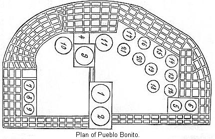
These structures ranged in extent from about four hundred to twelve hundred feet in external measurement and could furnish a home to from two hundred to eight hundred or a thousand Indians, and, in one case at least, many more.
In the next cut we have represented the different styles of masonry employed in the pueblos of this valley. It varied all the way from careful piling of big and little stones, and of alternate layers of such materials, to very good masonry indeed. Speaking of it, Mr. Jackson says, "It is the most wonderful feature in these ancient habitations, and is in striking contrast to the careless and rude methods shown in the dwellings of the present pueblos. The material, a grayish-yellow sandstone, breaking readily into thin laminae, and was quarried from the adjacent exposures of that rock. The stones employed average about the size of an ordinary brick, but as the larger pieces were irregular in size, the interstices were filled in with very thin plates of sandstone, or rather built in during its construction; for by no other means could they be placed with such regularity and compactness. So closely are the individual pieces fitted to each other that at a little distance no jointage appears, and the wall bears every indication of being a plain, solid surface."
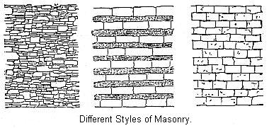
Besides these important ruins, there are a great many others not especially different from those previously described. We can not state positively that these ruins are of a later date than those of the North; we think they are. From the character of the structures, we are more inclined to class them with the great pueblos of the Rio Grande, Puerco, and Zuñi. By examining the map we see that the Rio Chaco would afford a convenient route for them in their migration from the San Juan Valley.
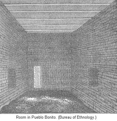
It may be of some interest to notice one of the rooms in this pueblo. Simpson says it is walled up with alternate layers of large and small stones, the regularity of the combination producing a very pleasant effect. Mr. Morgan thinks this room will compare not unfavorably with any of equal size to be found in the more imposing ruins of the South. We must notice the ceiling. The probabilities are that the Rio Chelly, further to the west, afforded another line of retreat. Some ruins are found scattered up and down the river or cañon, which we will not stop to describe. Off to the south-west are the inhabited towns or pueblos of the Moquis, who, as we have seen, have a tradition that they came from the north.
There are some ruins found in the south-western part of Arizona which must be described in a general survey of the ruins of the Pueblo country. The river Gila, with numerous tributaries, is the most important stream in that portion of the State. It is in just such a section as we would expect to find ruins, if anywhere. Coronado, as we have seen, invaded the country about three hundred and fifty years ago. At the time of his visit this was then a ruin, for his historian describes one ruin as "a single ruined and roofless house . . . the work of civilized people who had come from afar."28 This gives us a point as to the antiquity of some of the ruins in the Gila Valley. As we shall see, there is every reason to suppose that this section was at one time a thickly inhabited one.
From the similar character of the remains, we conclude the original inhabitants to be of the same race of people as those we have already described, but what was the exact relation between them we can not tell, but we think a study of the ruins will only confirm the general truth of the traditions of the Pueblo tribes. In any one tradition there is doubtless much that is distorted. One form in which the traditions find expression is: "That they proceeded from the north-west to the upper waters of the Rio Colorado. There they divided, portions ascended by the San Juan, cañon De Chelly, or the more easterly branches of that stream towards the center of New Mexico. Others, passing over the waters of the Rio Verde (see map), descended its valley to the Rio Gila."29
One hundred and fifty miles southwest of Zuñi we notice the Verde River flowing into the Rio Salado, and the latter into the Gila. Besides those streams, there are other smaller ones, not marked on the map.30 Mr. Bandelier found near the cañon del Tule an improvement on the irrigating ditches, that was a lining of concrete; and in this section also was noticed the ruins of both pueblos and the small houses. Near Ft. Apache he found the ruins of the largest villages discovered in Arizona, but we have no details of it. The valley of the Rio Verde and Salado seems to have been a favorite resort.
As early as 1854 attention was called to ruins in the Rio Verde. Mr. Leroux reported to Mr. Whipple that the "river banks were covered with ruins of stone houses and regular fortifications, which appeared to have been the work of civilized men, but had not been occupied for centuries. They were built upon the most fertile tracts of the valley, where were signs of acequias (irrigating ditches) and of cultivation. The walls were of solid masonry, of rectangular form, some twenty or thirty paces in length, were of solid masonry, and yet remaining ten or fifteen feet in height. The buildings were of two stories, with small apertures or loop-holes for defence, when besieged."31
Mr. Bandelier confirms this account as to the number of ruins. The entire valley of the Verde is filled with ruins of every description. From the account of the valley itself, we can see how well suited it was to the needs of village Indians. Mr. Leroux speaks in high praise of its fertility. Wood, water, and grass were abundant. In the neighborhood of Fort Reno Mr. Bandelier discovered a new architectural feature of great interest to us. This is a raised platform, on which the buildings were supported. This raised platform is a very important feature, as we shall learn in the ruins of Mexico and Central America. We have already seen how it was employed by the Mound Builders.
In other words, the detached houses are seen to form villages, with a central stronghold, and the tendency is observed to raise an artificial foundation for this central house, which draws into itself the surrounding houses. This is but another modification of the same idea which, in other sections of this area developed into the communal pueblo. Near Tempe a still more significant arrangement was noticed. Here was a four-sided platform, three hundred and forty feet long by two hundred and eighty feet wide, and five feet high, supported a second platform measuring two hundred and forty by two hundred feet, and six feet high. Elevated platforms, as a general rule, were not very distinct. Mr. Bandelier thinks that, owing to the peculiar drainage of the country, these artificial foundations were required to preserve the buildings from being swept away by a sudden torrent. The settlement of the sedentary tribes in this region cluster on the triangle formed by the Rio Verde, Salado, and Gila Rivers. "This is a warm region, with a scanty rainfall, and but little timber, and the soil is very fertile when irrigated, and two crops a year can be readily raised. Mr. Bandelier regards it as exceedingly well adapted to the wants of a horticultural people, and even traces in it some resemblance to Lower Egypt."
A very celebrated ruin on the Gila River gives us a fair idea of what this central stronghold of the village cluster, sometimes supported on a raised foundation, was like. This cut is a view of the principal ruin in this section, which, however, is only a portion of an extensive settlement, covering some five acres in all. The building is not very large, only fifty by forty feet, and four stories, of ten feet each, in height, with a possibility that the central portion of the building rose ten feet higher. The walls are built of adobe, five feet thick at the base, but tapering slightly at the top.
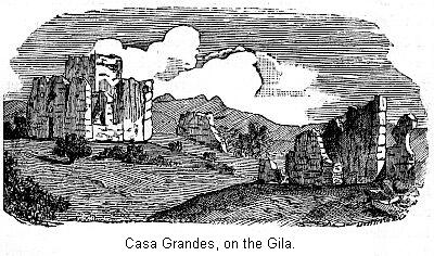
This house was surrounded by a court-yard which inclosed about two acres. Shapeless mounds, presumably the ruins of houses, are to be seen in various parts of this inclosure. "If the ground plan of this great house," says Mr. Bandelier, "with its surroundings of minor edifices, courts and inclosures is placed by the side of the ground plan of other typical ruins, the resemblance is almost perfect except in materials used." This settlement was separated into two divisions. In one place was noticed a large elliptical tank with heavy embankments, nearly eight feet deep.
As to other ruins on the Gila, Mr. Bartlett tells us: "One thing is evident, that at some former period the valley of the Gila was densely populated. The ruined buildings, the irrigating canals, and the vast quantities of pottery of a superior quality, show, that while they were an agricultural people, they were much in advance of the present semi-civilized tribes of the Gila." Speaking of the ruins of the Gila east of the San Pedro River, Emory says: "Whenever the mountains did not infringe too closely on the river and shut out the valley, they were seen in great abundance, enough, I should think, to indicate a former population of at least one hundred thousand; and in one place there is a long wide valley, twenty miles in length, much of which is covered with the ruins of buildings and broken pottery. Most of these outlines are rectangular, and vary from forty to fifty feet to two hundred by four hundred feet."32
It is, however, necessary to be very cautious in judging population by the number of ancient ruins. Prehistoric people were naturally of a roving disposition. The multitude of ruins in Western New York is not regarded as evidence of dense population, but they were occasioned by the known customs of the Indians in changing the sites of their villages "every ten, fifteen, or thirty years; or, in fact, whenever the scarcity of firewood, the exhaustion of their fields, or the prevalence of an epidemic made such a step desirable."33 Doubtless a similar remark may explain the difference of opinion as to the numbers of the Mound Builders.34 And, finally, Mr. Bandelier concludes that the great number of ruins scattered through New Mexico and its neighboring territories is by no means evidence of a large population. The evidence of tradition is to the effect that a large number of villages were successively, and not simultaneously, occupied by the same people.35
We have about completed our survey of the Pueblo country. We might state that the large communal houses, known as pueblos, are found as far south on the Rio Grande as Valverde. Clusters of separate houses occur as far south as Dona Ana. A range of low mountains lies to the west of the Rio Grande; between it and the headwaters of the Gila evidences of ancient habitations were observed on the small streams. Though these occur sometimes in little groups, the court-yards are not connected so as to form a defensive village. Small inclosed surfaces, with no evidence that a house ever was connected with them, were also observed. Mr. Bandelier could only surmise that these were garden-plots, something like the ancient terrace garden-plots in Peru.
Take it all in all, this is, indeed, a singular region, and the Pueblo tribes were a singular people. Their architecture shows us a people in the Middle Status of Barbarism. That they practised agriculture is shown by the presence of old irrigating ditches. Corn and corn-cobs are found in the rubbish-heaps of old settlements. Mr. Morgan thinks that the valley of the San Juan and its numerous tributaries was the place where the Indian race first rose to the dignity of cultivators of the soil.36 Cotton cloth has been found in the ruins on the Salado River. "At the time of the Spanish conquests the Pueblo Indians along the Rio Grande used cotton mantles."37
As we have devoted considerable time to the pottery of the Mound Builders, we must see how it compares with the pottery of this region. Fragments of pottery are very numerous all over the field of ruins. All explorers mention their abundance. Mr. Holmes on one occasion counted the pieces of pottery that by their shape evidently belonged to different vessels that he found in an area ten feet square. They numbered fifty-five, and we are led to believe they were not more numerous here than in other localities.
We recall that the ornamentations on the vessels of clay made by Mound Builders were either incised lines or indentations on the surface of the vessels. And, still further, the clay vessels themselves were frequently molded in the shape of animals or heads of animals. In this plate we have fragments of indented and corrugated ware, from the San Juan valley. This ware is only found under such circumstances indented and that we are justified in considering it very ancient. The ware made at the time of the conquest was always painted.
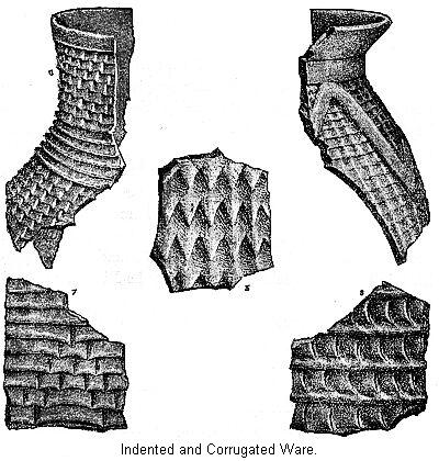
At Zuñi and some of the other pueblos, at the present day, they make vessels in the form of various animals and other natural objects. This is, however, a recent thing. Only one vessel is known that was found under such circumstances that we are justified in thinking it very old. That was molded into a shape resembling some kind of an animal. This was found on the Rio Gila, in New Mexico; and even that has some peculiarities about it that renders its age uncertain. Mr. Bandelier says: "No vessel of ancient date, of human or animal shape, has ever been found." This is a most important point for us to consider, when we recall how numerous were animal-shaped vessels among the Mound Builders.
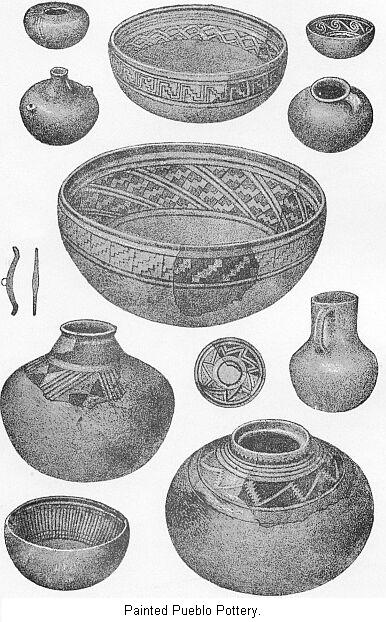
In this plate we have specimens of the ordinary painted ware from the ancient ruins. The most of these are restorations, but so many fragments have been obtained of each vessel that we have no doubt of the accuracy of the drawings. They decorated their pottery by painting. Even in many cases where they were further ornamented by indentations they still painted it, showing that painting was regarded as of the most importance. We notice that the ornamentation consists almost entirely of geometrical figures, parallel lines, and scrolls. Over the entire field of ruins the body of the vessels is of one of two colors; it is either white or red. The color employed to produce the ornamentation is black. There is almost no exception to this rule, though sometimes the ornamentation is of a brownish color with a metallic luster. Along the Rio Grande and the Gila some changes are noticed. The ornamentation is not strictly confined to two colors. Symbolical representations of clouds, whirlwind, and lightning are noticed. The red ware has disappeared, and a chocolate-colored ground takes its place.
All have noticed the superiority of the ancient pottery over that of the present tribes. Says Prof. Putnam. "A comparison of this ancient pottery with that made by the present inhabitants of the pueblos shows that a great deterioration has taken place in native American art, a rule which I think can be applied to all the more advanced tribes of America. The remarkable hardness of all the fragments of colored pottery which have been obtained from the vicinity of the old ruins in New Mexico, Colorado, Arizona, and Utah, and also of the pottery of the same character found in the ruins of adobe houses, and in caves in Utah, shows that the ancient people understood the art of baking earthenware far better than their probable descendants now living in the pueblos of New Mexico and Arizona."38
We have learned that the remnant of an aboriginal people, now living in the inhabited pueblos of the West, present us, in their primitive usage, with the fading outlines of a culture once widespread in the section of country we have examined. Many of the early sedentary tribes have vanished completely. Traditions state that other tribes have moved southward into regions unknown. "The picture which can be dimly traced to-day of this past is a very modest and unpretending one. No great cataclysms of nature, no wave of destruction on a large scale, either natural or human, appear to have interrupted the slow and tedious development of the people before the Spaniards came. One portion rose while another fell, sedentary tribes disappeared or moved off, and wild tribes roamed over the ruins of their former abode." At present but a few pueblos are left to show us what the people once were. But the fate of the Pueblo of Pecos hangs over them all. The rising tide of American civilization is rapidly surrounding them. Before many decades, possibly centuries, the present Pueblo tribes will yield to their fate. They, too, will be numbered among the vanished races of men.
REFERENCES- The manuscript of this chapter was submitted to Mr. Ad. F. Bandelier, of Highland, Illinois. As agent for the Archæological Institute of America, he spent three years in explorations in the Pueblo country.
- See an excellent historical account by Bandeliers: "Papers of the Archæological Institute of America." American series No. 1.
- The term "City of Zuñi" is scarcely correct; it should be Pueblo of Zuñi.
- Pacific Railroad Report; Whipple, Vol. III., pp. 67 and 68.
- "Archæological Institute of America," Fifth An. Rep., pp. 55 and 56.
- Bancroft's "Native Races," Vol. I., p. 534.
- His guide.
- The ruins on the top were, however, built after 1680, when the inhabitants of Flavona, the Spanish "Alvona," fled to the top of the mesa to escape the forays of the Navajos. The ruins were abandoned before 1705. Zuñi is partly built on the ruins of Flavona, which is still its aboriginal name. (Bandelier.)
- Pacific Railroad Reports, Whipple, Vol. III., p. 69.
- Pacific Railroad Reports, Whipple, Vol. III., p. 65.
- "Simpson's Report," p. 124.
- Dr. Loew, in "U.S. Geographical Survey West of the 100th Meridian," Vol. VII, p. 343.
- "Fifth An. Rep. Archæological Inst. of America," p. 61.
- Bandelier's "Papers of the Archæological Inst." p. 46.
- These facts are drawn from Mr. Bandelier's article already referred to.
- "Colorado River of the West," p. 119, et seq.
- U.S. Survey, Hayden, 1876, p. 390.
- Bandelier, "Fifth Annual Report Archæological Inst. of America," pp. 62, 68, and 65.
- "Contributions to North American Ethnology," Vol. IV, p. 172, et seq.
- Holmes.
- U.S. Survey, Hayden, 1876, p. 419.
- Rendered by Ingersoll, in N.Y. Tribune, Nov. 3, 1874.
- Bandelier, in Fifth Ann. Rep., Arch. Inst., p 79.
- U.S. Survey West of 100th M., Vol. VII, p. 358.
- "First Annual Report of Bureau of Ethnology," p. 74.
- "Fifth Annual Report Arch. Inst.," pp. 42, 78.
- Morgan: "Contribution to N. A. Ethnology," Vol. IV, p. 163.
- "Smithsonian Report," 1863, p. 313.
- Whipple, Pacific R. R. Report, Vol. III.
- Wherever reference is made to Mr. Bandelier's discoveries, it is taken from the oft-quoted Fifth Annual Report, Archæological Institute.
- Whipple, Pacific R. R. Reports, Vol. III., p. 14.
- Bartlett's "Personal Narrative."
- Carr's "Mounds of the Mississippi Valley."
- Morgan's "House and House Life," p. 218.
- Fifth Annual Report, p. 84.
- "Contributions to N. A. Ethnology," Vol. IV., p. 192.
- Bandelier's "Fifth Annual Report Arch. Inst.," p. 76.
- U.S. Survey West of 100th Meridian, Vol. VII., p. 381.
Chapter X: The Mound Builders.
Chapter XII: The Prehistoric Americans.
