

.
Almyros (Greek: Αλμυρός, which means salty) is a town and a municipality of the peripheral unit of Magnesia, periphery of Thessaly, Greece. It lies in the center of prosperous fertile plain known as 'Krokio Pedio', which is crossed by torrents, and produces wheat, tobacco, and other crops. Almyros is an important agricultural and commercial center of Magnesia, and is also developing as a tourist center for the area. The main agricultural products are tomatoes, cottons, wheats and dried nuts.
History
Further information: Byzantine Greece
The history of Almyros begins with the ancient city of Alos (about 10 km south of Almyros), the ruins of which can still be visited. Alos was a very important and populous town, famous for its port and for its role in the Persian Wars. After the Byzantine Empire, because of pirate raids, they built the town in the place that it is today.[CN] In 1838, the settlement was described as being "a Turkish town, situated on the western coast of the Pagasitic Gulf, half an hour's journey inland, on the Plain of Krokios, and consisting of some 300 dwellings. It is chiefly inhabited by Turks, with only a few Christian settlers, who cultivate the lands of the Turks residing there".[1] The Ottoman Empire ceded most of Thessaly in 1881, followed by development and repopulation by Greeks.
In 1980 a catastrophic magnitude 6.5 earthquake destroyed most of the town.[2]
Municipality
The municipality Almyros was formed at the 2011 local government reform by the merger of the following 4 former municipalities, that became municipal units:[3]
Almyros
Anavra
Pteleos
Sourpi
Subdivisions
The municipal unit of Almyros is divided into the following communities: Almyros, Efxeinoupoli, Anthotopos, Kokkotoi, Kroki, Kofoi, Platanos, and Fylaki.
Landmarks
The Archaeological Museum of Almyros includes local artifacts and exhibits from the Neolithic period, through Mycenean, Geometric, Classical, Hellenistic periods, and later Roman years.[4] Opposite the museum is the old High School, the Gymnasium of Almyros, which is a classic monumental building from the beginning of 20th century. The Museum and Gymnasium are the oldest buildings in the area.
The Kouri forest, about 2 km from the town of Almyros, encompasses coastal wetlands, brackish marshland, and over 10 km² of lowland oak forest. The forest provides a home to deer, roe deer, and other small fauna, while the area is important to migratory birds, such as the mute swan, spoonbill, glossy ibis, and various herons. There are footpaths, as well as a miniature train for a brief tour through the woods and over small bridges.[5]
There are several sandy beaches in the municipality of Almyros. South of the town are the moderately wooded Othrys mountains. 17 km from the town of Almyros but still in Almyros province, high in the Othrys mountains, is the 12th century Monastery of Panagia Xenia, with wall paintings, treasuries, and a library.[6][7]
Geography
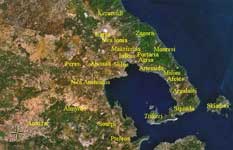
Almyros is linked with GR-1 and is passed by the old road. It is located 35 km SW of Volos, about 280 km (old prob. 320 km) NW of Athens, NNE of Lamia, E of Karditsa, ESE of Trikala, SE of Larissa and S of Thessaloniki.
Historical population
Year Town population Municipality population
1981 6,730[8] -
1991 8,502 14,046[9]
2001 7,566 12,987[9]
References
^ Almyros History. Retrieved 2007-07-12.
^ Drakos, Antonis G.; Stathis C. Stiros, and Anastasia A. Kiratzi. (2001-12). "Fault Parameters of the 1980 (Mw 6.5) Volos, Central Greece, Earthquake from Inversion of Repeated Leveling Data". Bulletin of the Seismological Society of America. bssa.geoscienceworld.org. Retrieved 2007-07-12.
^ Kallikratis law Greece Ministry of Interior (Greek)
^ Sights: Almyros' Archaeological Museum "All Hotels in Magnesia" website. Retrieved 2007-07-12.
^ Kouri Almyrou Hellenic Republic Ministry of Tourism. Retrieved 2007-07-12.
^ Magnesia Greece, History and Christianity Pelion. Thegreektravel.com (commercial website). Retrieved 2007-07-12.
^ The Sights of Almiros Greek Travel Pages (commercial website). Retrieved 2007-07-12.
^ Almyros (ALS), Town, Magnesia Greek Travel Pages (commercial website). Retrieved 2007-07-11.
^ a b Athena 2001 Hellenic Republic Ministry of Economy and Finance, National Statistical Service of Greece. Retrieved 2007-07-11.
|
Municipalities and communities of the Magnesia Prefecture
Afetes | Agria | Aisonia | Almyros | Alonnisos | Argalasti | Artemida | Feres | Iolkos | Karla | Milies | Mouresi | Nea Anchialos | Nea Ionia | Portaria | Pteleos | Sipiada | Skiathos | Skopelos | Sourpi | Volos | Zagora Anavra | Keramidi | Makrinitsa | Trikeri |
Greece :
A - B - C - D - E - F - G - H - I - J - K - L - M -
N - O - P - Q - R - S - T - U - V - W - X - Y - Z
| Ancient Greece
Science, Technology , Medicine , Warfare, , Biographies , Life , Cities/Places/Maps , Arts , Literature , Philosophy ,Olympics, Mythology , History , Images Medieval Greece / Byzantine Empire Science, Technology, Arts, , Warfare , Literature, Biographies, Icons, History Modern Greece Cities, Islands, Regions, Fauna/Flora ,Biographies , History , Warfare, Science/Technology, Literature, Music , Arts , Film/Actors , Sport , Fashion --- |
Retrieved from "http://en.wikipedia.org/"
All text is available under the terms of the GNU Free Documentation License
