

.
Administrative Region : West Greece
Regional unit : Ilia
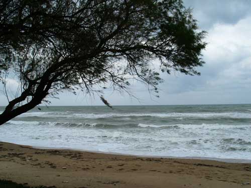
Kyllíni (Κυλλήνη, classically Cyllene or Kyllênê) has the westernmost port in the peninsula, and a touristic destination in which hotels are founded. The city has a population of around 2,200 with Kato Panagia. Founded nearly 3,000 years ago, the population hasn't changed as much until the mid-20th century. The population has been at 100 or 200 during ancient times, and surpassed over 500 or 600 in the mid-20th century. The location is around 20.05 E or 20' 03 E and 37.9 or 37' 54 N. Its length of coastline is about 11 km with beaches, rocks, and coast. Much of its creeks and streams are very dry, and run or flow only after rainy weather.
Geography and Information
Founded in front of the Ionian coastline, this town has plenty of hotels and villas like the Avocado. and a spring S of Kyllini has the same name. The westernmost point of the Peloponnese is one of the most touristic destinations in Elia. Most of the hill is covered with forests and olive trees. The plain covers only about 20% of the land, and Neochori is the only village lying. Beautiful restaurants that are looking at the sea is very neat. Most of the community is forested with the remainder is agricultural lands.
There is the peninsula's westernmost port, the Port of Kyllini is located meters east of the heart of Kyllini. Restaurants and stores are line up with a street overlooking at the sea.
There are gas stations, they number around 3, one in the heart of Kyllini, one heading eastward to Patras, ond heading westbound to Kastro, and one in east of Neochori facing westbound traffic to Kyllini, now Kastro.
Traffic along the road from Andravida to Kyllini is about 1,000 per hour during ferries into Kyllini which lasts for about 15 to 30 minutes. Rare before the mid-20th century, 500 in the 1980s.
The length of roads are about 10 km in length. 800 m are one-way streets. Restaurants are lined up on Neochori's, Kastro's and Kyllini's main streets.
A military base is located almost southeast. It contains luxury-sized houses for the refugees. It is surrounded by barbwire-gates, and meters off the Kyllini-Andravida Road, the former GR-84.
The nearest national road is the GR-9 or E55, which is 10km (originally 13km) ot the east.
There are no hospitals or health center. The closest health center is in Varda.
A monastery is located in Vlacherna southeast of Kato Panagia.
Chlemoutsi, a fortress was built to protect the invaders from other parts of Europe. Today it is abandoned, and turned into a tourist attraction. It sits on a top of the hill elevating 135 m above sea level and surrounded by pine trees and houses from Kastro. Lights pop up every night, and singers entertain at the fortress including Giorgos Dalaras (Giorgos Ntalaras).
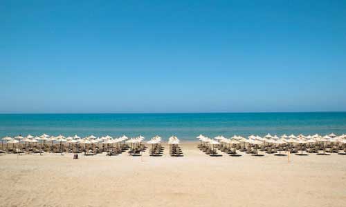
Thermal Springs of Kyllini or Kyllini Baths is the nicest place for a beach. It is the largest beahc facility in the western Peloponnese. In the mid-20th century, construction began on opening a spring linking with about 1 km of roads with parking lot 200 to 300 m from the sea with hot-sandy beach. Other facilities were also built. Then it was opened.
Since Kyllini is in an earthquake zone. This place has about a few strong earthquakes in community's history. Damages were the most in Elia when the Ionian Earthquake rumbled much of the Ionian region. Damages were close to minor and moderate. This earthquake happened in 1953.
Cape Kyllini is a cape located north of Kyllini. Its longitude is 21.1333/21°07' E and the latitude is 37.95/37°57' N.
Between the cape and Kyllini is a small fortress named Glarentza and slightly east is the beach.
It also offers a view of the island of Kefallinia from the north.
The island of Kafkalida is the only unhabited settlement. The island is rocky with two pine trees in the middle and has Kyllini's lighthouse. The lighthouse is about 20 to 30 m tall and is in the southern part of the island. It is accessed by a tiny port holding one or two boats and is not used for cars from the port of Kyllini. It is only accessed by a pathway. The northern half of the island are made up of rocks. The island about 100,000 years ago was connected with the mainland.
Agriculture
Agriculture used to dominate the entire job industry of Kyllini. Then other jobs came to town, and tourism is the primary source of industry, along with miscellaneous non-farm industry, and the port of Kyllini.
--------------------------------------------------------------------------------
Former Municipality of Kástro-Kyllíni
The municipality's population is around 3,000 to 3,500 people. Most of the population lives in Kyllini-Kato Panagia where the total population is 2,392. The largest is Kato Panagia and Kyllini, the seat is the second. And the rest live along the coast. 80% of the total population lives in urban areas. The remainder remains ruralized. The boundaries run west of Myrsini on a creek. It is the westernmost municipality in Elia and the Peloponnese. The municipal boundaries are bounded north and west of Machos, and north of Démetra/Diacutelmitra.
There are water towers in Kyllíni and Neochóri.
There are forests south of Neochori, north of Machos, and on the hilltops, especially near the west coast of Kyllini. Fertile land are founded mostly on a plain, and on hill, including olive trees.
Its length of coastline is about 16km, from W of Lygia around to W of Myrsini Beach.
The length of roads is about 30 to 35 km. 800 m are one-way streets, walkways are rare. The length of railroads had disappeared by an opening of a Neochori bypass. Railways used to cover 9 km. There are no more trains running in the area anymore. Along with the Neochori and Kyllini railroad stations and even one electric and three hand-operated crossings (totaling four) the rest didn't have any. They are abandoned. 15 trains used to run this track. Speed limit on these roads is 20 km/h for surfaced roads, 30 to 40 km/h on hilly slopes, including 4 km of Andravida-Kyllini road and narrow unused roads, and 60 km/h on by-pass and paved flat roads. About 5 to 10% are lined with bamboo sticks and about 10% are lined up with pines and other kinds of trees. Only its phone lines exist in front of the bush and grass-covered abandoned train tracks. 4 km of hydro lines opened around 2002, powers hydro to the island of Zante by the Greek (Hellenic) Hydro (ΔΕΗ, DEI or DE-E).
Loutra Kyllinis
The first paved road was Andravida to Kyllini road which was surfaced until the 1960s, then came Loutra Kyllini Road in the late-1960s, Kastro-Kyllini road came after, and road to Machos and road from Kastro to Kyllini came in the 1970s and to Kavasilas in the 1980s. Only less than a quarter of its roads were actually paved. In 1999, a new paved road opened for about 800 m which made traffic to Vlacherna made easier. Cars don't have to go around to follow the signs to the monastery. The distance was cut by 2 km. Distance from Neochori to Vlacherna is now 6 km from 8 km And from Lechaina 10 km from 12 km and before that, 14 km. The only road not paved which is about 4 km from Kastro is that narrow road connecting from Vlacherna to Kastro. Kyllini may pave that treacherous surfaced road to make better use of that route. About more than 40% to 50% of its road are actually paved. The other roads that do not link to villages especially country roads remain surfaced.
There are nearly 1,500 buildings, units, hotels and hotel units, and houses in the municipality alone.
Agriculture consists of tomatoes, watermelons, potatoes, and corn in the plains, while pasture lands, and olive production are very dominant because most of the municipality is hilly. Agriculture used to be dominant in their business before the 1960s.
Most of the hotels after the late-20th century were built after the 1980s lead by a sharp increase in tourism. There were only a few hotels in the region. An increase in tourism lead to expansion of hotels.
The campgrounds include
Thermal Springs of Kyllini: Camping Melissa Beach
Kyllini: Avocado
Kyllini has a school, a lyceum, a gymnasium a church, banks, a post office, gas stations, restaurants and a square (plateia).
Population
| Year | Communal population | Municipal population |
|---|---|---|
| 1981 | - | - |
| 1991 | 952 | 4398 |
| 2001 | 1079 | 4486 |
The community includes the villages and towns of:
| Community | Population | Elevation |
|---|---|---|
| Kyllíni (Κυλλύνη) Kafkalida (one of the smallest in Greece) |
around 1,000 (metro. 2,000) | sea level to 10 m (30 ft.) |
|
Káto Panagiá and Vlácherna Ikaros (pop: 558) less than 800 sea level to 25 m (80 ft.) |
less than 800 | sea level to 25 m (80 ft.) |
| Neochori (Kyllini), Greece Vytineika (pop: 28) |
less than 900 | 5 to 7 m (15 to 22 ft.) |
| Kastro
- Psili Rachi |
around 200 | 110m (380 ft.) |
| Thermal Springs of Kyllini | less than 10 | sea level to 15 m (50 ft.) |
| Western half of Arkoudi | less than 100 | sea level to 30 m (100 ft.) |
Western half of Arkoudi less than 100 sea level to 30 m (100 ft.)
Greece :
A - B - C - D - E - F - G - H - I - J - K - L - M -
N - O - P - Q - R - S - T - U - V - W - X - Y - Z
| Ancient Greece
Science, Technology , Medicine , Warfare, , Biographies , Life , Cities/Places/Maps , Arts , Literature , Philosophy ,Olympics, Mythology , History , Images Medieval Greece / Byzantine Empire Science, Technology, Arts, , Warfare , Literature, Biographies, Icons, History Modern Greece Cities, Islands, Regions, Fauna/Flora ,Biographies , History , Warfare, Science/Technology, Literature, Music , Arts , Film/Actors , Sport , Fashion --- |
Retrieved from "http://en.wikipedia.org/"
All text is available under the terms of the GNU Free Documentation License
