

.
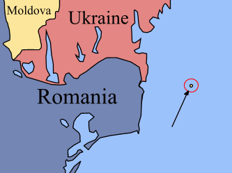
Map of Snake Island
Snake Island (also known as Serpent Island; Ukrainian: ostriv Zmiyinyy, Romanian: Insula şerpilor) lies in the Black Sea off the coasts of Romania and Ukraine. The island is part of the Kiliya Raion (district) of Odessa Oblast, Ukraine. The continental shelf around Snake Island is a subject of the ongoing Romania-initiated protracted litigation before the International Court of Justice (see below).
The island is a limestone formation located 35 km from the coast, east of the mouth of the Danube River. Island's coordinates are 45°15’18’’N and 30°19’15’’E. The island is X-shaped, 662 meters by 440 meters, covering an area of 0.17 km². The highest point is 41 m above the sea level. The island is close to the Ukrainian part of Danube Delta. The nearest city on the coast is Sulina, Romania, which is 45 km away. The closest Ukrainian city is Vilkovo.
Population and Infrastructure
About 100 inhabitants live on the island, mostly frontier guard servicemen with their families and technical personnel. Since 2003 a permanent scientific expedition by Odessa National University has been located on the island.
The island is currently demilitarized and is under rapid development. In accordance with 1997 Treaty between Romania and Ukraine, the Ukrainian authorities withdrew an army radio division, demolished military radar, and transferred all other infrastructure to civilians.
addition to a helicopter platform, in 2002 a pier has been build for ships with up to 8 meter draught, and harbour construction is underway. The island is supplied with navigation equipment, including a 150-year old lighthouse. Electric power is provided by a dual wind/diesel power station. The island also has such civil infrastructure as a post office, a bank branch (of Ukrainian bank "Aval"), a first-aid station, satellite television, a phone network, a cell phone tower, and an Internet link.
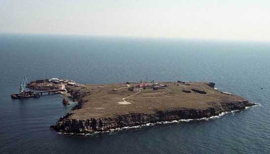
Image of the Snake Island (captured from helicopter of Ukrainian frontier guards)
History
The island was named, by the Greeks, Λευκός, Leuce Island ("White Island"), similarly known by Romans as Alba, probably because of the white marble formations that can be found on the isle. The uninhabited Isle Achilleis ("of Achilles") was the major sanctuary of the Achaean hero, where "seabirds dipped their wings in water to sweep the temples clean" (Kyriazis). Several temples of Thracian Apollo can be found here, and there are submerged ruins.
According to an epitome of the lost Trojan War epic of Arktinos, the remains of Achilles and Patroclus were brought to this island by Thetis, to be put in a sanctuary. Ruins believed to be of a square temple dedicated to Achilles, 30 meters to a side, were discovered by Captain Kritzikly in 1823. Ovid, who was banished to Tomis, mentions the island; so do Ptolemy and Strabo[1]. The island is described in Pliny's Natural History, IV.27.1.
Several ancient inscriptions were found on the island, including a 4th century BC Olbiopolitan decree which praises someone for defeating and driving out the pirates that lived on the "holy island". The Ottomans renamed it Fidonisi; the island gives its name to the naval Battle of Fidonisi (1789).
Modern history
In 1877, following the Russo-Turkish War, Russia gave Romania control of the island and Dobrogea region (with Mangalia district), as a reimbursement for the Russian annexation of Romania's southern Bessarabia region.
The Paris Peace Treaties of 1947 between the protagonists of World War II ceded Northern Bukovina, the Hertza region, Budjak, and Bessarabia to the USSR but made no mention of the mouths of the Danube and Snake Island.
In 1948, the Soviets forced the Romanian side (occupied by Soviet troops) to accept the "transfer" of Snake Islands to the USSR as well as to accept to move the Romanian border in the Danube Delta towards the west, in favour of the USSR (resulting in the annexation of Limba Island by the USSR). Romania has strongly disputed the validity of this "treaty" since it was never ratified by any of the two countries making the Limba and Snake islands de jure Romanian territory.
The same year, in 1948, during the Cold War, a Soviet radar post was built on the isle (for both naval and anti-aircraft purposes).
Soviet's posession of Snake Islands was confirmed in the Treaty between the Government of the People's Republic of Romania and the Government of the Union of the Soviet Socialist Republics on the Romanian-Soviet State Border Regime, Collaboration and Mutual Assistance on Border Matters, signed at Bucharest on February 27, 1961.
Between 1967 and 1987, the USSR and Romanian side were negotiating the delimitation of the continental shelf. The Romanian side refused to accept a Russian offer of 4000 km² out of 6000 km² around the island in 1987.
After 1991, Ukraine took control over the isle, although Romania consistently claimed it should be included in its territory. According to the Romanian side, in the peace treaties of 1918 and 1920 (after WWI), the isle was considered part of Romania, and it was not mentioned in the 1947 frontiers changing treaty between Romania and the Soviet Union.
In 1997 Romania and Ukraine signed a treaty in which both States "reaffirm that the existing border between them is inviolable and therefore, they shall refrain, now and in future, from any attempt againts the border, as well as from any demand, or act of, seizure and usurpation of part or all the territory of the Contracting Party". Romania agreed with the terms of the treaty, as it opened for the country a door to NATO. However, both sides have agreed that if no resolution on maritime borders can be reached within two years, then either side can go to the International Court of Justice to seek a final ruling.
Maritime Delimitation
Due to the isle's geographic position, its possession dramatically affects the maritime frontier line between the two countries. If Snake Island is not an island, but a cliff, then in accordance with international law the maritime boundary between Romania and Ukraine should be drawn without taking into consideration the isle location. If Snake Island is an island, then continental shelf around Snake Island should be considered as Ukrainian water.
The Romanian side claims that Ukraine is developing the isle in order to prove it's island status (as contrary to a cliff). Romanians also claims that this is a violation of the Romanian-Ukrainian Treaty of 1997, which stipulated that the island should remain uninhabited.
On 16 September 2004 the Romanian side brought a case against Ukraine to the International Court of Justice in a dispute concerning the maritime boundary between the two States in the Black Sea, claiming that the island has no socio-economic significance [1]. Ukraine has to respond by 19 May 2006 [2]
Recently, oil (10 million tonnes) and gas deposits (1 billion m³) were discovered under the seabed nearby. The natural resources are not significant though, as they can be exhausted in 2-3 year of development.
BP and Royal Dutch/Shell signed prospect contracts with Ukraine, while Total with Romania. Austrian OMV (the owner of Romania's largest oil company, Petrom) also signed a contract with Naftogaz Ukrainy and Chornomornaftogaz to jointly participate to an auction for a concession of the area.
Presuming that the ICJ finds its jurisdiction in this dispute, the following picture may arise. In general, the islands are “special” or “relevant” circumstances to be considered in each act of delimitation effected either by states themselves or with the help of a third party, such as the ICJ, and depending on the peculiarity of a given situation, considerations of equity may lead to giving islands full, partial or even no effect in determining entitlement to maritime areas. However, in the practice of states even rocks are often given effect during maritime delimitation, leaving alone fully-fledged islands. For example, Aves Island was given full effect in the US/Venezuela Maritime Boundary Agreement despite its very small size and lack of habitation . Furthermore, most states do not distinct the islands from LOSC Art. 121(3) “rocks” and claim the shelf and the EEZ for all their rocks and islands . Examples would include the UK (with regard to Rockall Island) , Japan (with regard to Okinotorishima), the US (with regard to Hawaiian and many other uninhabited islands along the equator), France (with regard to Clipperton and other islands), Norway (with regard to Jan Mayen), Yemen, Nicaragua, Sri Lanka etc . The practice of international courts, tribunals and other third-party dispute settlement bodies is less uniform. On the one hand, even alleged Art.121(3) “rocks” are taken into account in delimiting the maritime boundaries . On the other hand, even though the islands are not Art.121(3) “rocks”, they may well be either ignored or substantially discounted (enclaved or eliminated) if their use would have an inequitable distorting effect in light of their size and location . Even if such islands are not discounted their actual influence on the delimitation is often minimal. All these decisions cannot, however, be said to have reached that level of uniformity in order to become a rule of law. Although there have as well been some other instances where the issue, similar to that between Ukraine and Romania, was directly or implicitly involved , there has not been so far any direct third-party international review of whether a particular feature is LOSC Art.121(3) “rock” or is Art.121(2) “island” . Therefore, the Romanian-Ukrainian dispute may be the first case where the question of whether or not the island constitutes a “rock” with all the following implications under LOSC Art. 121(3) after its adoption will be examined by the main international adjudicative forum . The decision of the ICJ in this case is not, therefore, that easy to predict. On the one hand, it seems obvious that the Serpents’ Island is the fully-fledged island under LOSC Art.121(2), it has the capacity to generate all maritime zones and may affect the maritime delimitation to the full extent. On the other hand, in delimiting the maritime zones, the ICJ may take into account “special” or “relevant” circumstances (the fact that the Black Sea is the “enclosed or semi-enclosed sea” which would make the maritime delimitation more difficult , the presence of the Serpents’ island, its location, significance etc.) and give the Serpents’ Island either full, or some, or none effect
| Ancient Greece
Science, Technology , Medicine , Warfare, , Biographies , Life , Cities/Places/Maps , Arts , Literature , Philosophy ,Olympics, Mythology , History , Images Medieval Greece / Byzantine Empire Science, Technology, Arts, , Warfare , Literature, Biographies, Icons, History Modern Greece Cities, Islands, Regions, Fauna/Flora ,Biographies , History , Warfare, Science/Technology, Literature, Music , Arts , Film/Actors , Sport , Fashion --- |
Retrieved from "http://en.wikipedia.org/"
All text is available under the terms of the GNU Free Documentation License
