

.
Administrative Region : Peloponnese
Regional unit : Messinia
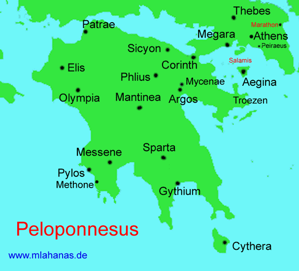
Pylos Area today
Pylos (Greek: Πύλος, Pylos), historically known under its Italian name Navarino, is a town and a former municipality in Messenia, Peloponnese, Greece. Since the 2011 local government reform it is part of the municipality Pylos-Nestoras, of which it is the seat and a municipal unit.[1] It was the capital of the former Pylia Province. Nearby villages include Gialova, Elaiofyto, Schinolakka, and Palaionero. The town of Pylos has 2,561 inhabitants, the municipal unit of Pylos 5,402 (2001).
Old Pylos and New Pylos are distinct settlements and castles, several kilometers apart. Old Pylos (Navarino Vecchio) is located on the northwest of the bay, while New Pylos is located in the southeast.
The bay of Pylos was the site of two naval battles:
the Battle of Pylos, in 425 BC during the Peloponnesian War
the Battle of Navarino, in 1827 during the Greek War of Independence.
The Name of Navarino
In the Middle Ages, Pylos was named Avarino (Αβαρίνος), probably after a body of Avars who settled there.[CN] Hopf's theory that it comes from the Navarrese Company[2] is chronologically unsustainable.[3] It was later called Navarino, with the incorporation of the ν of the article τον. Another theory suggests it is a Slavic name meaning "place of maples".[4]
The Venetian name was "Zonklon" (from Greek Ionchion), the Turkish name (1498-1821) "Anavarin" (with another round of epenthesis), and the local Greek name "Neokastron" 'new castle'.[5]
Other names recorded for the town and the castles are Avarmus, Abarinus, Albarinos, Albaxinus, Avarinos, Coryphasium, Iverin, Nelea, Port de Jonc, Porto Giunco, and Zunchio.
Geography
Pylos from the north.
The soil about Navarino is of a red colour, and is remarkable for the production of an infinite quantity of squills, which are used in medicine. The rocks, which show themselves in every direction through a scanty but rich soil, are limestone, and present a general appearance of unproductiveness round the castle of Navarino; and the absence of trees is ill compensated by the profusion of sage, brooms, cistus, and other shrubs which start from the innumerable cavities of the limestone.
The remains of Navarino Vecchio, or ancient Navarino, consist of a fort, covering the summit of a hill sloping quickly to the south, but falling in abrupt precipices to the north and east. The town was built on the southern declivity, and was surrounded by a wall, which, allowing for the natural irregularities of the soil, represented a triangle, with the castle at the summit—a form observable in many of the ancient cities of Greece.
Bay of Pylos
Pylos' bay is formed by a deep indenture in the Morea, shut in by a long island, anciently called Sphacteria or Sphagia (modern name Sfaktiria), famous for the defeat and capture of the Spartans, in the Battle of Pylos during the Peloponnesian War, and still showing the ruins of walls which perhaps formed their last refuge. This island has been divided into three or four separate sections by the violence of the waves, and boats could pass from the open sea into the port, in calm weather, using the channels so formed. One such section contains the tomb of a Turkish saint, or santon, called the Delikli Baba. This same section also contains a monument to the French sailors who died at the Battle of Navarino; the monument to the Russian dead of the same battle is on the island of Sphacteria, while the monument to the English dead is on another very small island near the centre of the port. Monuments and tombs from the Greek War of Independence are on the island of Sphacteria, the most important being the monument to the Italian philhellene Santorre di Santa Rosa.
Flora and Fauna
The Gialova wetland is a regional blessing of nature. It is one of 10 major lagoons in Greece.[6] and has been classified as one of the important bird areas in Europe[7]. It has also been listed as a 1500-acre archaeological site, lying between Gialova and the bay of Voidokilia. Its alternative name of Vivari is Latin, meaning 'fishponds'. With a depth, at its deepest point, of no more than four meters, it is the southernmost stopover of birds migrating from the Balkans to Africa, giving shelter to no fewer than two hundred and twenty-five bird species, among them heron, cormorant, the lesser kestrel, Audouin's, gull, flamingo, osprey,the imperial eagle, and other aquatic species.[8] It is Gialova, too, which plays host to a vary rare species, nearing extinction throughout Europe, the African chameleon. The observation post of the Greek Ornithological Society allows visitors to find out more and to watch the shallow brackish waters of the lake, they can walk the paths that circumscribe Gialova's different ecosystems.[9]
History
The continuous human presence, of which there is evidence from as long ago as the Neolithic Age. In later times -in the Bronze Age, Pausanias tell us - there was a prosperous settlement. Homer also quote 'Sandy Pylos' in Book 17 of the Odyssey about Telemachus travelling to Sparta in search of news of his father Odysseus.
We left for Pylos, nestor too
the shepherd of the peoples,
And He, receiving me the king,
within his halls so lofty,
Embraced me with all
eagerness as father does
his youngling
His son back from long time abroad.
Homer, Odyssey
IX 108-112
In the Geometric period, probably, there was a battle with Sparta, a grievous page in the military history of the Pylians. Thucydides devotes several chapters to their conflict with Athens, and there is a famous marble statue, Paeonius Victory - dedicated by the people of Naupactus and Messenia and now in the museum of Ancient Olympia. Archaeological finds in the area have mostly been from tombs, bearing witness to the fact that in the following periods of history - Hellenistic and Roman times- Pylos remained a flourishing burgh.
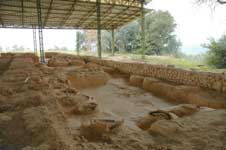
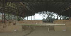
Bronze Age Pylos
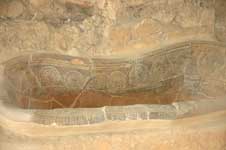
Bronze Age Pylos was excavated by Carl Blegen between 1939 and 1952. It is located at modern Ano Englianos, about 9 km north-east of the bay 37.028°N 21.695°E. Blegen called the remains of a large Mycenean palace dating from 1300 BC. found there the "Palace of Nestor", after the character Nestor, who ruled over "Sandy Pylos" in the Homeric poems. Linear B tablets found by Blegen clearly demonstrate that the site itself was called Pylos (Mycenaean Greek Pulos, Linear B Pu-ro) by its Mycenaean inhabitants. This site was abandoned sometime after the 8th century BC and burned to the ground. The ruins of a crude stone fortress on nearby Sphacteria Island, apparently of Mycenaean origin, were used by the Spartans during the Peloponnesian War. (Thucydides iv. 31)
Classical Pylos
The site of classical Pylos was probably on the rocky promontory now known as Koryphasion at the northern edge of the bay of Pylos. This site is described by the Greek historian Thucydides in his History of the Peloponnesian War. In 425 BC the Athenian politician Cleon sent an expedition to Pylos, to seize and occupy the bay. The Athenians captured a number of Spartan troops on the adjacent island of Sphacteria (see Battle of Sphacteria). Spartan anxiety over the return of the prisoners, who were taken to Athens as hostages, contributed to their acceptance of the Peace of Nicias in 421 BC.
Byzantine Avarino or Navarino
The Naval Battle of Navarino , by Ambroise Louis Garneray.
The fortress of Pylos.
Venetian and Ottoman era
The Venetians built fortresses both at Paleokastro and (much later) at Niokastro The Ottoman Empire took Navarino from the Venetians in 1499. They rebuilt the Venetian old fortress in 1572, under the name Anavarin-i atik.
Administratively, Anavarino was a kaza.
In 1668, Evliya Çelebi describes the city in his Seyahatname:
Anavarin-i atik is an unequalled castle... the harbor is a safe anchorage...
in most streets of Anavarin-i cedid [New Navarino] there are many fountains of running water... The city is embellished with trees and vines so that the sun does not beat into the fine marketplace at all, and all the city notables sit here, playing backgammon, chess, various kinds of draughts, and other board games....
Starting in 1686, the Venetians tried to retake Navarino and the rest of the Morea, but were finally defeated in 1715. The Ottomans started rebuilt the fortress of New Navarino, Anavarin-i Cedid, (which had been heavily damaged) immediately thereafter. There was another round of repairs in 1770.
The Modern Town
Pylos harbour by boat, September 2010
The western end of Greek National Road 82 begins in downtown Pylos. The highway runs west to east and links Pylos with Kalamata and Sparta. The area enjoys a famously favorable climate, with especially mild winters.
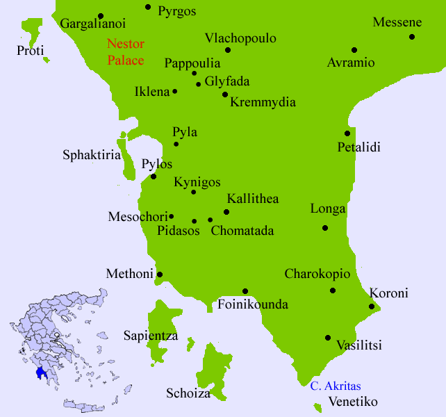
Subdivisions
The municipal unit Pylos is subdivided into the following communities:
Ampelokipoi
Chomatada
Glyfada
Iklaina
Kallithea
Kynigos
Mesochori
Pappoulia
Pidasos
Pyla
Pylos
Historical population
Year Town population Municipality population
1981 2,594 -
1991 2,014 5,340
2001 2,104 5,402
See also
Communities of Messenia
Palace of Nestor
Petrohori
References
Sandy Pylos: An Archaeological History from Nestor to Navarino (rev. ed.) 2nd Edition by Jack L. Davis (Editor), John Bennet (Editor)
^ Kallikratis law Greece Ministry of Interior (Greek)
^ Hopf, "Geschichte Griechenlands vom Beginn des Mittelalters", in Allgemeine Encyklopaedie
^ Encyclopedia of Islam s.v. Navarino; William Miller, "The Name of Navarino", The English Historical Review 20:78 (April 1905), pp. 307-309
^ Max Vasmer. Die Slaven in Griechenland, 1941, as cited in W.A. McDonald, G.R. Rapp. The Minnesota Messenia Expedition: Reconstructing a Bronze Age Regional Environment, University of Minnesota Press, 1972, p.65. ISBN 0-816-60636-6
^ Encyclopedia Britannica, 11th edition, 1911, s.v. Pylos
^ Cultural Corridors of South Europe
^ Mediterranean Wetlands Conference, June 5th-9th 1996, Venice, Italy
^ Surfbirds web site
^ EUROPA Youth
Notes
John Bennet, Jack L. Davis, Fariba Zarinebaf-Shahr, "Pylos Regional Archaeological Project, Part III: Sir William Gell's Itinerary in the Pylia and Regional Landscapes in the Morea in the Second Ottoman Period", Hesperia 69:3:343-380 (July-September, 2000) at JSTOR
Fariba Zarinebaf, John Bennet, and Jack L. Davis, A Historical and Economic Geography of Ottoman Greece: The Southwestern Morea in the 18th century, Hesperia Supplement 34, Princeton, 2005. ISBN 0-87661-534-5. A study combining archaeological and survey results with information from the Ottoman archives.
Diana Gilliland Wright, book review of Zarinebaf et al., Electronic Journal of Oriental Studies 8:10:1-16 (2005). A very complete summary of Zarinebaf. PDF.
Jack L. Davis (ed.), Sandy Pylos. An Archaeological History from Nestor to Navarino. Second edition. Princeton, NJ: ASCSA Publications, 2008. Pp. lix, 342; figs. 135.
|
Municipalities and communities of the Messinia Prefecture
Aetos | Aipeia | Andania | Androusa | Arfara | Aris | Aristomenis | Avia | Avlona | Chiliochora | Dorio | Eira | Filiatra | Gargalianoi | Ithomi | Kalamata | Koroni | Kyparissia | Lefktro | Meligalas | Messene | Methoni | Nestoras | Oichalia | Pappaflessa | Petalidi | Pylos | Thouria | Voufrades |
| Municipal unit Pylos |
|---|
| Municipal Community Pylos |
| Gialova (Γιάλοβα, η) |
| Elaiofyto (Ελαιόφυτον, το) |
| Παλαιόνερον, το |
| Pylos (Πύλος, η) |
| Σφακτηρία, η (νησίς) |
| Schinolakka (Σχινόλακκα, η) |
| Community Ampelokipoi |
| Ampelokipoi (Αμπελόκηποι, οι) |
| Kato Ampelokipoi (Κάτω Αμπελόκηποι, οι) |
| Community Glyfada |
| Glyfada (Γλυφάδα, η) |
| Community Iklaina |
| Iklaina (Ίκλαινα, η) |
| Community Kallithea |
| Αραπόλακκα, η |
| Kallithea (Καλλιθέα, η) |
| Community Kynigos |
| Βοζικέικα, τα |
| Kynigos (Κυνηγός, ο) |
| Community Mesochori |
| Mesochori (Μεσοχώρι, το) |
| Community Pappoulia |
| Pappoulia (Παππούλια, τα) |
| Platanos (Πλάτανος, ο) |
| Community Pidasos |
| Pidasos (Πήδασος, η) |
| Community Pyla |
| Μπαλοδημαίικα, τα |
| Pyla (Πύλα, η) |
| Community Chomatada |
| Perivolakia (Περιβολάκια, τα) |
| Chomatada (Χωματάδα, η) |
Greece :
A - B - C - D - E - F - G - H - I - J - K - L - M -
N - O - P - Q - R - S - T - U - V - W - X - Y - Z
| Ancient Greece
Science, Technology , Medicine , Warfare, , Biographies , Life , Cities/Places/Maps , Arts , Literature , Philosophy ,Olympics, Mythology , History , Images Medieval Greece / Byzantine Empire Science, Technology, Arts, , Warfare , Literature, Biographies, Icons, History Modern Greece Cities, Islands, Regions, Fauna/Flora ,Biographies , History , Warfare, Science/Technology, Literature, Music , Arts , Film/Actors , Sport , Fashion --- |
Retrieved from "http://en.wikipedia.org/"
All text is available under the terms of the GNU Free Documentation License
