

.
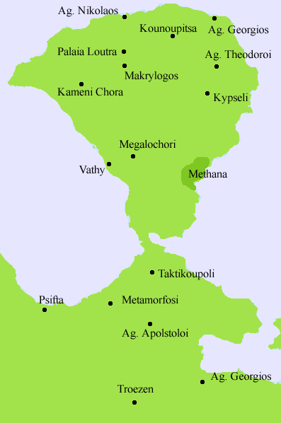
Kameni Chora (or Kaimeni Chora) (Greek: Καμένη Χώρα, meaning burnt town which the name is derived from a nearby volcano of Methana) is a village located in the northwestern part of the Methana peninsula. It is located in a valley northwest of the volcanic summit. It is located W of Methana, E of Ligouri, NE of Kranidi, ENE of Ermioni, NW of Troizina and W of Poros.
Geography
- Location:
- Longitude: 21.335 (21°20'4') E
- Latitude: 38.614 (38°36'55') N
- Longitude: 21.335 (21°20'4') E
- Population: 45 (1991)
- Postal code: 180 30
- Elevation:
- lowest: around 200 to 250 m
- centre: around 300 to 350 m
- highest: about 412 m
- lowest: around 200 to 250 m
- Dialing code: +11+30-22980 (030-22980)
Kameni Chori has a small school, a chapel of Agios Sotirios and a square (plateia). Residential houses and within the low valley in the west-central part and has grasses with a few trees to its east. The rocky landscape and bushes are to the west and east. Much of the area are bushy. The forests are founded within the valleys and around the old faded crater rim. It is the place where the last eruption happened in around 276 BC at the elevation of 412 to 417 m and another in 1700. Much of the population are farmers and is agfriculturally known. The main production are olive, almonds and wine. Tourism is also becoming popular especially at the tavern bar Ifaisteio or Ifestio on a road linking to Cape Kalo Koumbaro.
The volcano of the mountain top includes some red fractured rocks at the steep of the lava dome. Fracts of trees are grown around the unactive volcano. The name of the volcano is Malia Vgethi (Μάλια Βγέθι) which the name comes from Albanian. The elevation is 680 m located next to the tallest mountain in the peninsula. It is in the foot of Kameni Choria. The volcano has a roughly arranged crater which the northern, the eastern and the southern part are deforested but the southern part has some forests but the western part has a mountain top. It is a historical volcano. It was active about 150,000 years ago and consists of andacite and Dacite, It is difficult to mount and is the most impressing volcanoes in the Saronic Gulf and one of over 30 in Methana. It is among the obkects of the Troezen area and Methana along with the landscape. There is a gravel road which is approximately 45 m to the crater. The volcano was investigated and studied by geologists like Washington, Foque, R. V. Leyden and V. Dietrich.
The extinct volcano includes panorama of the southern half of the peninsula along with parts of the northeastern Peloponnese, western and southwestern Attica including Kakia Skala, parts of Aegina and the islands of Angistri, Kyra and a smaller one further north and the Saronic Gulf.
| Ancient Greece
Science, Technology , Medicine , Warfare, , Biographies , Life , Cities/Places/Maps , Arts , Literature , Philosophy ,Olympics, Mythology , History , Images Medieval Greece / Byzantine Empire Science, Technology, Arts, , Warfare , Literature, Biographies, Icons, History Modern Greece Cities, Islands, Regions, Fauna/Flora ,Biographies , History , Warfare, Science/Technology, Literature, Music , Arts , Film/Actors , Sport , Fashion --- |
