

.
Periphery: Crete
Prefecture : Chania
Anatoliko Selino municipality (Source)
Anatoliko Sélino (Greek: Δήμος Ανατολικού Σέλινου) is a municipality on the south coast of the island of Crete, Greece. It is part of the Selino province which covers much of the mountain and coastal region west of Sfakia.
The head town of the municipality is Kabanos (or Kampanos). The other villages include Rodovani, Skafi, Sougia, Temenia, Epanochori. Sougia is a growing resort but is still small due to the inaccessibility of the region. The villages formed individual communities previously but were joined as a municipality in 1997.
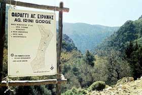
Agia Eirini (or Agia Irini) Gorge, named after the nearby village in the north entrance. A 7.5 km gorge.
Division of the municipality, population 1468 (2001):
Kampanos / Δ.δ. Καμπανού [ 245 ]
Maralia / τα Μαράλια [ 40 ]
Epanochori / Δ.δ. Επανωχωρίου [ 361 ]
Epanochori / το Επανωχώρι [ 114 ]
Agia Eirini / η Αγία Ειρήνη [ 84 ]
Prines / ο Πρινές [ 133 ]
Seliniotikos Gyros / ο Σελινιώτικος Γύρος [ 0 ]
Tsiskiana / τα Τσισκιανά [ 30 ]
Rodovani / Δ.δ. Ροδοβανίου [ 336 ]
Rodovani / το Ροδοβάνι [ 122 ]
Skafi / Δ.δ. Σκάφης [ 167 ]
Skafi / η Σκάφη [ 70 ]
Argastiri / το Αργαστήρι [ 35 ]
Pera Skafi / η Πέρα Σκάφη [ 62 ]
Sougia / Δ.δ. Σούγιας [ 262 ]
Koustogerako / το Κουστογέρακο [ 76 ]
Temenia / Δ.δ. Τεμενίων [ 97 ]
Pappadiana / τα Παππαδιανά [ 14 ]
Stratoi / οι Στράτοι [ 6 ]
Agia Eirini
Rodovani is a municipal district , population 336 with the synonymous village Rodovani (population 122). Near Rodovani are the remains of the ancient city of Elyrus which is described by Pausanias
Temenia
Near Temenia and Pappadiana was the ancient city Hyrtacina (or Yrtakina) In Temenia also there is a spring-spa. Because of the healthy water, there is a small hotel and a refreshments' factory .
Coordinates:
Longitude: 23o 46' 40" E
Latitude: 35o 17' 15" N
Tsiskiana
In Tsiskiana is located the Byzantine church of Aghios Eutychis, who is the patron saint of the whole Selino prefecture. Every summer on saint's day (August 24th), a traditional feast is organised.
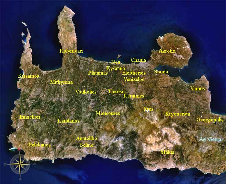
Chania Municipalities, Satellite Image
|
Divisions of the Chania prefecture Provinces of the Chania prefecture Apokoronas | Kissamos | Kydonia | Selino | Sfakia Municipalities of the Chania prefecture Akrotiri | Anatoliko Selino | Armeni | Chania | Eleftherios Venizelos | Fres | Georgioupoli | Innachori | Kandanos | Keramia | Kissamos | Kolymvari | Kryonerida | Mousouri | Mythimna | Nea Kydonia | Pelekanos | Platanias | Sfakia | Souda | Theriso | Vamos | Voukolies Non-municipal communities of the Chania prefecture |
Greece :
A - B - C - D - E - F - G - H - I - J - K - L - M -
N - O - P - Q - R - S - T - U - V - W - X - Y - Z
| Ancient Greece
Science, Technology , Medicine , Warfare, , Biographies , Life , Cities/Places/Maps , Arts , Literature , Philosophy ,Olympics, Mythology , History , Images Medieval Greece / Byzantine Empire Science, Technology, Arts, , Warfare , Literature, Biographies, Icons, History Modern Greece Cities, Islands, Regions, Fauna/Flora ,Biographies , History , Warfare, Science/Technology, Literature, Music , Arts , Film/Actors , Sport , Fashion --- |
Retrieved from "http://en.wikipedia.org/"
All text is available under the terms of the GNU Free Documentation License
